
Cemetery #13889
Mülheim Cemetery
Local name: Friedhof Mülheim
Also known as Mülheimer Friedhof
0
documented records
≈ 4,000–8,100
approx. capacity (graves)
0.202 km²
cemetery area
Oct 18, 2026
last modified
About this cemetery
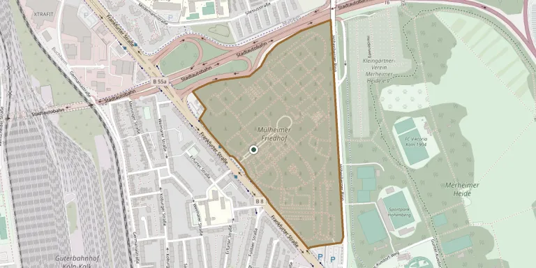
Mülheim Cemetery is a municipal cemetery in the Höhenberg district of Cologne, on Frankfurter Straße. It was established on 30 September 1904, after the citizens of Mülheim am Rhein had previously buried their dead in two separate denominational cemeteries. The three-part gatehouse at the main entrance dates from 1903.
Cemetery location
GPS coordinates: 50.946911° N, 7.023801° E Directions in Google Maps (opens in a new tab)
Memorials
No records yet
Photograph a headstone and add it to the archive.
Looking for someone who isn't listed? Request a photo.
Nearby cemeteries
The closest other burial grounds listed on EveryStone.
- Kalker Cemetery 1.4 km away · Köln · 38 records
- Köln Old Catholic Cemetery 1.4 km away · Köln
- Köln-Mülheim Evangelical Cemetery 1.9 km away · Cologne Region
- Holweide Cemetery 2.4 km away · Cologne Region
- Mülheim Jewish Cemetery 3.1 km away · Köln
- Gedenkstätte für Opfer von Krieg und Gewaltherrschaft 3.4 km away · Köln
- von Andreae Family Burial Ground at Mielenforst Estate 3.5 km away · Köln Kalk
- Deutz Jewish Cemetery 3.6 km away · Cologne Region
- Deutzer Cemetery 3.7 km away · Köln-Innenstadt
- Brück Cemetery 4.0 km away · Köln-Kalk · 19 records
Contribute with the app
Our website works smoothly on both desktop and mobile devices. Prefer a native app? Check it out below.
- Capture clear headstone photos
- Save GPS grave locations automatically
- Transcribe inscriptions with our AI
- Suggest corrections to existing records
Common questions
How big is Mülheim Cemetery?
Mülheim Cemetery covers about 20.2 hectares (202,000 m²), about the same size as Bellu Cemetery in Bucharest. It is the 64th largest of the 4,061 cemeteries we list in North Rhine-Westphalia.