
Cemetery #167978
Lutwyche Cemetery
0
documented records
≈ 2,000–4,000
approx. capacity (graves)
0.100 km²
cemetery area
Oct 18, 2026
last modified
About this cemetery
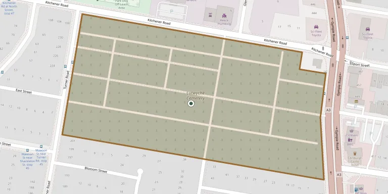
Lutwyche Cemetery is in Kedron, about ten kilometres north of central Brisbane, at the corner of Gympie and Kitchener Roads. It opened in 1878, with its first burial in the same year, and is one of Brisbane's oldest cemeteries. It has a grid-like layout, is managed by Brisbane City Council and includes Commonwealth war graves.
Cemetery location
GPS coordinates: 27.400780° S, 153.028890° E Directions in Google Maps (opens in a new tab)
Memorials
No records yet
Photograph a headstone and add it to the archive.
Looking for someone who isn't listed? Request a photo.
Nearby cemeteries
The closest other burial grounds listed on EveryStone.
- Nundah Cemetery 3.9 km away · Brisbane
- Mitchelton (Saint Matthew) Anglican Churchyard 6.1 km away · Brisbane
- Albany Creek Memorial Park 6.6 km away · Brisbane
- Pinnaroo Lawn Cemetery and Crematorium 6.6 km away · Brisbane
- Nudgee Catholic Cemetery 7.0 km away · Brisbane
- Milton Christ Church (Anglican) Memorial Reserve 7.5 km away · Brisbane
- Albany Creek (Faheys Road East) Cemetery 8.2 km away · Brisbane
- Bulimba/Balmoral Cemetery 8.6 km away · Brisbane
- Sandgate (Bald Hills) Cemetery 9.2 km away · Brisbane
- The Gap (Uniting) Church/Graveyard 9.3 km away · Brisbane
Contribute with the app
Our website works smoothly on both desktop and mobile devices. Prefer a native app? Check it out below.
- Capture clear headstone photos
- Save GPS grave locations automatically
- Transcribe inscriptions with our AI
- Suggest corrections to existing records
Common questions
How big is Lutwyche Cemetery?
Lutwyche Cemetery covers about 10 hectares (100,000 m²), about the size of 14 soccer fields. It is the 31st largest of the 364 cemeteries we list in Queensland.