
Cemetery #190447
Har HaMenuchot Cemetery
Local name: הר המנוחות
Also known as Ar AMenuchot · Har Menuẖot · הר מנוחות
0
documented records
≈ 12k–25k
approx. capacity (graves)
0.625 km²
cemetery area
Oct 18, 2026
last modified
About this cemetery
Har HaMenuchot is the central Jewish cemetery of Jerusalem, opened in 1951 after the Mount of Olives cemetery became inaccessible following the 1948 fighting. It lies on a hill about 750 metres above sea level on the western side of the city and serves all of Jerusalem's communities. Rabbi Aharon Rokeach of Belz is among those buried here. For enquiries, call +972 2-625-2281 or see matara.pro.
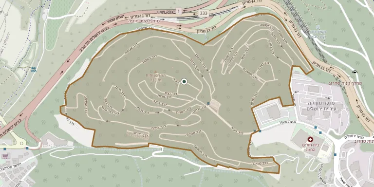
Cemetery location
GPS coordinates: 31.798167° N, 35.178816° E Directions in Google Maps (opens in a new tab)
Memorials
No records yet
Photograph a headstone and add it to the archive.
Looking for someone who isn't listed? Request a photo.
Nearby cemeteries
The closest other burial grounds listed on EveryStone.
- Beit Zayit Cemetery 2.3 km away · Jerusalem
- Mount Herzl National Military Cemetery 2.4 km away · Jerusalem
- Shaare Zedek Cemetery 2.9 km away · Jerusalem
- Sheikh Badr Cemetery 3.2 km away · Jerusalem
- Sanhedriya Jerusalem Cemetery 4.0 km away · Jerusalem
- Mamilla Cemetery 4.5 km away · Jerusalem
- Mamila Cemetery 4.5 km away · Jerusalem
- Beit Nekofa Cemetery 4.6 km away · Beit Neqofa
- A Sa'ira Cemetery 5.2 km away · Jerusalem
- Kiryat Anavim Cemetery 5.4 km away · Beit Nekofa
Contribute with the app
Our website works smoothly on both desktop and mobile devices. Prefer a native app? Check it out below.
- Capture clear headstone photos
- Save GPS grave locations automatically
- Transcribe inscriptions with our AI
- Suggest corrections to existing records
Common questions
How big is Har HaMenuchot Cemetery?
Har HaMenuchot Cemetery covers about 62.5 hectares (625,000 m²), about the same size as Fiumei Road Cemetery in Budapest. It is the largest of the 52 cemeteries we list in Jerusalem District.