
Cemetery #216204
Mountain Grove Cemetery
Also known as Mount Grove Cemetery · Mountain Grove Cemetery Association
0
documented records
≈ 8.3k–17k
approx. capacity (graves)
0.416 km²
cemetery area · 102.8 acres
Oct 18, 2026
last modified
About this cemetery
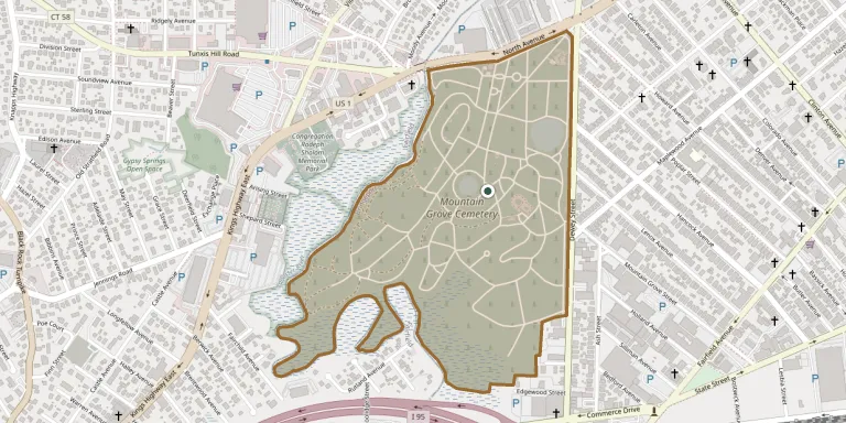
Mountain Grove Cemetery in Bridgeport, Connecticut, was laid out in 1849 in the rural cemetery style at the corner of North Avenue and Dewey Street. It is described as a garden cemetery founded by P. T. Barnum and is the burial place of Tom Thumb. It is run by the Mountain Grove Cemetery Association.
Cemetery location
GPS coordinates: 41.173466° N, 73.221051° W Directions in Google Maps (opens in a new tab)
Memorials
No records yet
Photograph a headstone and add it to the archive.
Looking for someone who isn't listed? Request a photo.
Nearby cemeteries
The closest other burial grounds listed on EveryStone.
- Congregation Rodeph Shalom Memorial Park 460 m away · Fairfield
- Congregation B'nai Israel Cemetery 540 m away · Bridgeport
- Congregation Rodeph Sholom Cemetery 580 m away · Bridgeport
- Eintracht Sick & Benefit Cemetery 580 m away · Bridgeport
- Old Stratfield Cemetery 770 m away · Bridgeport
- Saint James Cemetery 1.2 km away · Bridgeport
- Hebrew Benefit Association Cemetery 1.6 km away · Fairfield
- Congregation Shaare Torah Adath Israel Cemetery 1.7 km away · Tunxis Hill
- Lawncroft Cemetery 2.1 km away · Fairfield
- Loyalty Cemetery 2.1 km away · Fairfield
Contribute with the app
Our website works smoothly on both desktop and mobile devices. Prefer a native app? Check it out below.
- Capture clear headstone photos
- Save GPS grave locations automatically
- Transcribe inscriptions with our AI
- Suggest corrections to existing records
Common questions
How big is Mountain Grove Cemetery?
Mountain Grove Cemetery covers about 41.6 hectares (103 acres), about the same size as Père Lachaise Cemetery in Paris. It is the 4th largest of the 1,408 cemeteries we list in Connecticut.