
0
documented records
≈ 1,300–2,500
approx. capacity (graves)
0.063 km²
cemetery area · 15.6 acres
Oct 18, 2026
last modified
About this cemetery
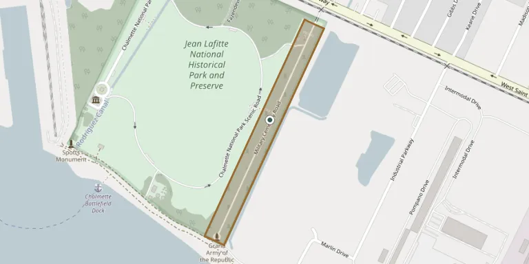
Chalmette National Cemetery was established in May 1864 as a final resting place for Union soldiers who died in Louisiana during the Civil War. It is a rectangular parcel measuring 250 feet by 2,200 feet, running from the Mississippi River on the south to West Saint Bernard Highway on the north. The cemetery is one of six sites within Jean Lafitte National Historical Park and Preserve.
Cemetery location
GPS coordinates: 29.941485° N, 89.988001° W Directions in Google Maps (opens in a new tab)
Memorials
No records yet
Photograph a headstone and add it to the archive.
Looking for someone who isn't listed? Request a photo.
Nearby cemeteries
The closest other burial grounds listed on EveryStone.
- Freedmen's Cemetery, Chalmette 140 m away · Chalmette
- Saint Bernard Memorial Gardens 2.9 km away · Chalmette
- Ellen Cemetery 2.9 km away · Chalmette
- McDonoghville Cemetery 5.8 km away · Gretna
- Saint Vincent de Paul Cemetery #3 6.0 km away · New Orleans
- Hughes Cemetery 6.0 km away · New Orleans
- Westlawn Memorial Park and Mausoleum 6.6 km away · Terrytown
- Westlawn South Cemetery 7.1 km away · Terrytown
- Saint Roch Cemetery #02 7.2 km away · New Orleans
- Saint Roch Cemetery #1 7.2 km away · New Orleans
Contribute with the app
Our website works smoothly on both desktop and mobile devices. Prefer a native app? Check it out below.
- Capture clear headstone photos
- Save GPS grave locations automatically
- Transcribe inscriptions with our AI
- Suggest corrections to existing records
Common questions
How big is Chalmette National Cemetery?
Chalmette National Cemetery covers about 63,000 m² (16 acres), about the size of 12 American football fields. It is the 75th largest of the 2,588 cemeteries we list in Louisiana.