
Cemetery #238037
Leverington Cemetery
0
documented records
≈ 860–1,700
approx. capacity (graves)
0.043 km²
cemetery area · 10.6 acres
Oct 18, 2026
last modified
About this cemetery
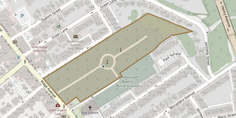
Leverington Cemetery is a non-denominational cemetery in the Roxborough neighborhood of Philadelphia, established in 1745. It occupies land that was originally the 1690s farm of the settler Wigard Levering. Local civilians and both Revolutionary War and Civil War soldiers are buried there, and it still accepts new burials. It adjoins the Roxborough Baptist Church Yard without any boundary between them.
Cemetery location
GPS coordinates: 40.033939° N, 75.213139° W Directions in Google Maps (opens in a new tab)
Memorials
No records yet
Photograph a headstone and add it to the archive.
Looking for someone who isn't listed? Request a photo.
Nearby cemeteries
The closest other burial grounds listed on EveryStone.
- Roxborough Baptist Church Cemetery 80 m away · Philadelphia
- Bethany German Lutheran Cemetery 540 m away · Philadelphia
- Saint Timothy's Episcopal Church Cemetery 740 m away · Philadelphia
- Saint John the Baptist Catholic Church Cemetery 1.1 km away · Philadelphia
- Saint Mary of the Assumption Cemetery 1.3 km away · Philadelphia
- St David's Episcopal Churchyard 1.3 km away · Manayunk
- First Presbyterian Church of Manayunk Churchyard 1.4 km away · Philadelphia
- Westminster Cemetery 1.9 km away · Bala Cynwyd
- West Laurel Hill Cemetery 2.2 km away · Bala Cynwyd
- Upper Burial Ground, Philadelphia 3.0 km away · Philadelphia
Contribute with the app
Our website works smoothly on both desktop and mobile devices. Prefer a native app? Check it out below.
- Capture clear headstone photos
- Save GPS grave locations automatically
- Transcribe inscriptions with our AI
- Suggest corrections to existing records
Common questions
How big is Leverington Cemetery?
Leverington Cemetery covers about 43,000 m² (11 acres), about the size of 8 American football fields. It is the 747th largest of the 5,268 cemeteries we list in Pennsylvania.