
Cemetery #26942
Robermont Cemetery
Local name: Cimetiere de Robermont
Also known as Begraafplaats van Robermont · Carrés militaires de Robermont · Militair plot Robermont Cemetery
0
documented records
≈ 7.5k–15k
approx. capacity (graves)
0.376 km²
cemetery area
Oct 27, 2026
last modified
About this cemetery
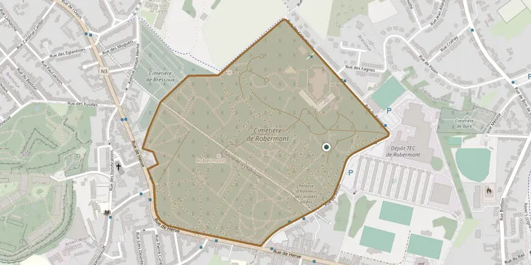
Robermont Cemetery in Liège is the city's main municipal cemetery and covers more than 40 hectares. The city decided in 1783 to stop burials inside the town for sanitary reasons, and the cemetery was created by the city council in 1805. It also contains First World War graves of Allied prisoners of war. More about the cemetery can be found through ww1cemeteries.com.
Cemetery location
GPS coordinates: 50.633518° N, 5.613670° E Directions in Google Maps (opens in a new tab)
Memorials
No records yet
Photograph a headstone and add it to the archive.
Looking for someone who isn't listed? Request a photo.
Nearby cemeteries
The closest other burial grounds listed on EveryStone.
- Pelouse d'honneur des armées alliées 160 m away · Liège
- Robermont Cemetery German Plot 300 m away · Liège
- Bure Cemetery 480 m away · Liège
- Bressoux Cemetery 560 m away · Bressoux
- Jupille-Bruyères Cemetery 820 m away · Bressoux
- Grivegnée-Servais-Malaise Cemetery 940 m away · Bois de Breux
- Grivegnée-Église Cemetery 1.4 km away · Bois de Breux
- Grivegnée-Centre Cemetery 1.4 km away · Grivegnée
- Chênée-Sart-Moray Cemetery 2.0 km away · Grivegnée
- Jupille-Saint-Amand Cemetery 2.1 km away · Jupille-sur-Meuse
Contribute with the app
Our website works smoothly on both desktop and mobile devices. Prefer a native app? Check it out below.
- Capture clear headstone photos
- Save GPS grave locations automatically
- Transcribe inscriptions with our AI
- Suggest corrections to existing records
Common questions
How big is Robermont Cemetery?
Robermont Cemetery covers about 37.6 hectares (376,000 m²), about the same size as Glasnevin Cemetery in Dublin. It is the largest of the 531 cemeteries we list in Liège.