
Cemetery #311902
Mayen Jewish Cemetery Heritage Zone
Local name: Denkmalzone Jüdischer Friedhof
0
documented records
≈ 25–51
approx. capacity (graves)
1,260 m²
cemetery area
Oct 18, 2026
last modified
About this cemetery
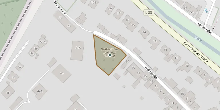
The Jewish cemetery on Waldstraße is designated a heritage zone in the north-west of Mayen's old town and covers 20.42 ares. Its oldest gravestone dates from 1640. The older Jewish cemetery at the forest edge near the Schützenplatz was destroyed by bombs in 1944, and its 31 remaining gravestones were moved to the new cemetery after the site was levelled in 1945. Visitors can ring +49 2651 880 or check alemannia-judaica.de.
Cemetery location
GPS: GPS coordinates: 50.333433° N, 7.217845° E Directions in Google Maps (opens in a new tab)
Memorials
No records yet
Photograph a headstone and add it to the archive.
Looking for someone who isn't listed? Request a photo.
Nearby cemeteries
The closest other burial grounds listed on EveryStone.
- Mayen Cemetery 1.4 km away · Mayen · 20 records
- Helgoland Cemetery 2.1 km away · Sankt Johann
- Sankt Johann Cemetery 2.2 km away · Sankt Johann
- Ettringen Cemetery 2.7 km away · Ettringen
- Kottenheim Cemetery 3.2 km away · Kottenheim
- Hausen Cemetery 3.9 km away · Hausen
- Alzheim Cemetery 3.9 km away · Alzheim
- Kürrenberg Cemetery 4.2 km away · Kürrenberg
- Thür Cemetery 4.4 km away · Thür
- Fraukirch Jewish Cemetery 5.1 km away · Fraukirch
Contribute with the app
Our website works smoothly on both desktop and mobile devices. Prefer a native app? Check it out below.
- Capture clear headstone photos
- Save GPS grave locations automatically
- Transcribe inscriptions with our AI
- Suggest corrections to existing records
Common questions
How big is Mayen Jewish Cemetery Heritage Zone?
Mayen Jewish Cemetery Heritage Zone covers about 1,260 m² (0.3 acres), about the size of 5 tennis courts. It is the 515th smallest of the 3,001 cemeteries we list in Rhineland-Palatinate.