
0
documented records
≈ 4–8
approx. capacity (graves)
210 m²
cemetery area
Oct 18, 2026
last modified
About this cemetery
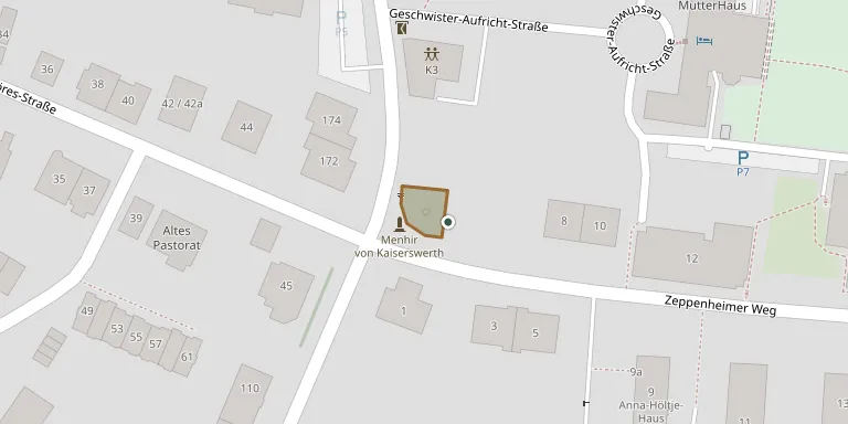
This small Jewish cemetery stands at the corner of Alte Landstraße and Zeppenheimer Weg in the Kaiserswerth district of Düsseldorf. It is first documented in 1737, and the last burial took place in 1937. It has been a listed monument since 2004, and the city installed new information panels there in 2022. Visitors can ring +49 211 172020 or check visitduesseldorf.de.
Cemetery location
GPS coordinates: 51.299000° N, 6.743190° E Directions in Google Maps (opens in a new tab)
Memorials
No records yet
Photograph a headstone and add it to the archive.
Looking for someone who isn't listed? Request a photo.
Nearby cemeteries
The closest other burial grounds listed on EveryStone.
- Kaiserswerth Cemetery 270 m away · Katholische Kirche, Evangelische Kirche · 15 records
- Fronberg Cemetery, Kalkum 320 m away · Kalkum
- Kaiserswerth Evangelical Cemetery 1.3 km away · Düsseldorf
- Kalkum Cemetery 1.3 km away · Zeppenheim
- St. Remigius Catholic Cemetery 2.1 km away · Einbrungen
- Lohausen Catholic Cemetery 2.5 km away · Düsseldorf
- Wittlaer Cemetery 2.6 km away · Bockum
- Lank II Cemetery 3.5 km away · Lank-Latum
- Unterrath Monastery Cemetery 4.0 km away · Düsseldorf
- Düsseldorf Monastery Cemetery 4.1 km away · Düsseldorf
Contribute with the app
Our website works smoothly on both desktop and mobile devices. Prefer a native app? Check it out below.
- Capture clear headstone photos
- Save GPS grave locations automatically
- Transcribe inscriptions with our AI
- Suggest corrections to existing records
Common questions
How big is Kaiserswerth Jewish Cemetery?
Kaiserswerth Jewish Cemetery covers about 210 m², about the size of a tennis court. It is the 65th smallest of the 4,061 cemeteries we list in North Rhine-Westphalia.