
Cemetery #407655
Beirut Martyrs' Cemetery
Local name: مقبرة الشهداء في بيروت
Also known as مقابر بيروت · Cimetière des martyrs de Beyrouth
0
documented records
≈ 1,100–2,200
approx. capacity (graves)
0.055 km²
cemetery area
Oct 18, 2026
last modified
About this cemetery
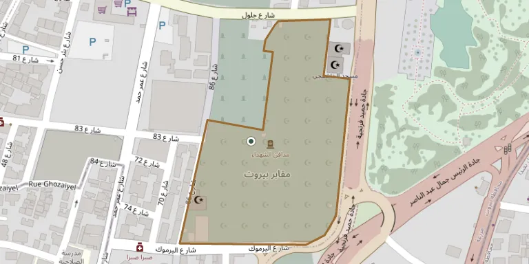
The Martyrs' Cemetery is one of the best-known Muslim cemeteries in Beirut. It was created in 1958 during the armed unrest of that year, when access to the Bachoura cemetery had become difficult. It extends from the Shatila roundabout along the road to Beirut airport towards the land adjoining Sabra Street.
Cemetery location
GPS: GPS coordinates: 33.868056° N, 35.505278° E Directions in Google Maps (opens in a new tab)
Memorials
No records yet
Photograph a headstone and add it to the archive.
Looking for someone who isn't listed? Request a photo.
Nearby cemeteries
The closest other burial grounds listed on EveryStone.
- Martyrs Cemetery 70 m away · Beirut
- Mqaber el Franj 100 m away · Beirut
- Beirut War Cemetery 240 m away · Beirut
- Beirut Polish War Cemetery 270 m away · Beirut
- Forest Cemetery 430 m away · Beirut
- Al Tayouneh Cemetery 540 m away · Beirut
- Rawdat al-Shaheedein Cemetery 580 m away · Beirut
- Ra's al Nab' Cemetery 1.8 km away · Beirut
- Ras-el Nabeh Greek Catholic Cemetery 1.8 km away · Beirut
- Saint John The Baptist Orthodox Cemetery 1.9 km away · Beirut
Contribute with the app
Our website works smoothly on both desktop and mobile devices. Prefer a native app? Check it out below.
- Capture clear headstone photos
- Save GPS grave locations automatically
- Transcribe inscriptions with our AI
- Suggest corrections to existing records
Common questions
How big is Beirut Martyrs' Cemetery?
Beirut Martyrs' Cemetery covers about 55,000 m² (14 acres), about the size of 8 soccer fields. It is the largest of the 18 cemeteries we list in Beirut Governorate.