
0
documented records
≈ 320–630
approx. capacity (graves)
0.016 km²
cemetery area
Oct 18, 2026
last modified
About this cemetery
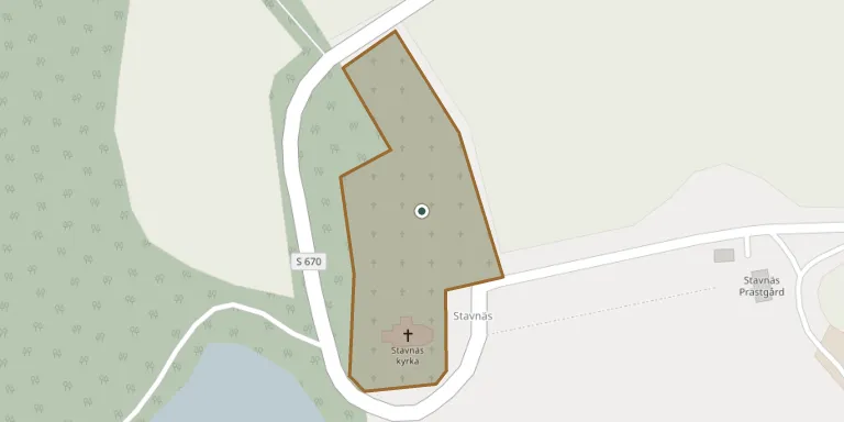
Stavnäs churchyard surrounds Stavnäs church in Stavnäs parish, Arvika Municipality, and has been documented since the 1600s. From the late 1700s it was enlarged several times to the north. A parish storehouse from the early 1800s stands west of the church by the shore, and a whitewashed mortuary dates from 1947. A stone circle that once stood here was destroyed when its area was absorbed into the churchyard.
Cemetery location
GPS coordinates: 59.484595° N, 12.738954° E Directions in Google Maps (opens in a new tab)
Memorials
No records yet
Photograph a headstone and add it to the archive.
Looking for someone who isn't listed? Request a photo.
Nearby cemeteries
The closest other burial grounds listed on EveryStone.
- Värmskog Churchyard 11 km away · Värmskog
- Högerud Churchyard 11 km away · Högerud
- Högerud Old Churchyard 11 km away · Högerud
- Glava Churchyard 13 km away · Glava
- Gillberga Churchyard 18 km away · Väsby
- Borgviks Churchyard 20 km away · Norra Borgvik
- Brunskog Cemetery 21 km away · Arvika
- Arvika Churchyard 21 km away · Arvika
- Långseruds Churchyard 23 km away · Backa
- Älgå Churchyard 23 km away · Östra Skyberg
Contribute with the app
Our website works smoothly on both desktop and mobile devices. Prefer a native app? Check it out below.
- Capture clear headstone photos
- Save GPS grave locations automatically
- Transcribe inscriptions with our AI
- Suggest corrections to existing records
Common questions
How big is Stavnäs Churchyard?
Stavnäs Churchyard covers about 16,000 m² (3.9 acres), about the size of 2 soccer fields. It is the 50th largest of the 107 cemeteries we list in Värmland.