
Cemetery #8770
All Saints Churchyard, Misterton
Also known as All Saints Church, Misterton
3
documented records
≈ 110–230
approx. capacity (graves)
5,680 m²
cemetery area
Oct 18, 2026
last modified
About this cemetery
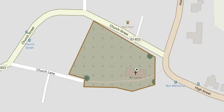
The churchyard of All Saints' Church in Misterton, Nottinghamshire, occupies an unusual position in the extreme south-east corner of the parish. The church itself shows architectural development from the 13th to the 19th century and is a Grade I listed building. On the 1886 Ordnance Survey map, several small buildings stood in the south-western corner of the churchyard.
Cemetery location
GPS coordinates: 53.444248° N, 0.850083° W Directions in Google Maps (opens in a new tab)
Memorials
3 memorials, A–Z by surname.
Looking for someone who isn't listed? Request a photo.
Nearby cemeteries
The closest other burial grounds listed on EveryStone.
- Misterton New Cemetery 640 m away · Misterton
- Saint Peter Churchyard 2.3 km away · East Stockwith
- St Mary Magdalene, Walkeringham 2.7 km away · Walkeringham · 2 records
- Beecher Lane Cemetery, Beckingham 4.5 km away · Beckingham
- All Saints Churchyard 4.7 km away · Beckingham · 4 records
- Gringley on the Hill St Peter and St Paul 5.0 km away · Gringley on the Hill · 2 records
- St Nicholas Churchyard 5.0 km away · Haxey
- Wildsworth Cemetery 5.2 km away · Laughton with Wildsworth
- Gringley on the Hill Cemetery 5.4 km away · Gringley on the Hill
- North Warren Cemetery 5.8 km away · Gainsborough
Contribute with the app
Our website works smoothly on both desktop and mobile devices. Prefer a native app? Check it out below.
- Capture clear headstone photos
- Save GPS grave locations automatically
- Transcribe inscriptions with our AI
- Suggest corrections to existing records
Common questions
How big is All Saints Churchyard, Misterton?
All Saints Churchyard, Misterton covers about 5,680 m² (1.4 acres), about the size of a soccer field. It is the 92nd largest of the 249 cemeteries we list in Nottinghamshire.
What is the oldest grave in this cemetery?
The oldest grave among the records we hold for All Saints Churchyard, Misterton is that of William Hallifield, who died on April 8, 1893 at the age of 52.