
Santa Fe
192 known cemeteries in Santa Fe, Argentina.
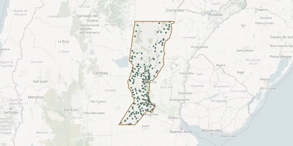 © OpenStreetMap
- Castelar CemeteryGPS coordinates: 31.66573° S, 62.08529° W
- Cayastá CemeteryGPS coordinates: 31.20019° S, 60.17438° W
- Centeno CemeteryGPS coordinates: 32.30171° S, 61.41658° W
- Ceres CemeteryGPS coordinates: 29.85671° S, 61.91031° W
- Ceres Jewish CemeteryGPS coordinates: 29.85772° S, 61.90612° W
- Chabás Communal CemeteryGPS coordinates: 33.25217° S, 61.37334° W
- Chovet CemeteryGPS coordinates: 33.61341° S, 61.61628° W
- Clucellas CemeteryGPS coordinates: 31.45625° S, 61.71593° W
- Colonia Aldao CemeteryGPS coordinates: 30.98965° S, 61.72510° W
- Colonia Cello CemeteryGPS coordinates: 31.42292° S, 61.85603° W
- Colonia Dolores Community CemeteryGPS coordinates: 30.39247° S, 60.33502° W
- Colonial Private Park CemeteryGPS coordinates: 31.26085° S, 61.52052° W
- Colonia Rosa CemeteryGPS coordinates: 30.29336° S, 61.98805° W
- Coronel Bogado CemeteryGPS coordinates: 33.30883° S, 60.61155° W
- Crispi CemeteryGPS coordinates: 31.73266° S, 62.05076° W
- Díaz Cemetery near MonjeGPS coordinates: 32.39566° S, 61.10390° W
- Diego de Alvear CemeteryGPS coordinates: 34.36439° S, 62.13662° W
- Elisa CemeteryGPS coordinates: 30.70886° S, 61.04119° W
- Elortondo CemeteryGPS coordinates: 33.71141° S, 61.62641° W
- El Prado CemeteryGPS coordinates: 32.98913° S, 60.74949° W
- El Rabón Communal CemeteryGPS coordinates: 28.22555° S, 59.25554° W
- El Salvador CemeteryGPS coordinates: 32.95434° S, 60.66617° W
- El Trébol Municipal CemeteryGPS coordinates: 32.21440° S, 61.69300° W
- Emilia Communal CemeteryGPS coordinates: 31.06277° S, 60.73901° W
- Esperanza Municipal CemeteryGPS coordinates: 31.47536° S, 60.94760° W
- Eusebia y Carolina CemeteryGPS coordinates: 30.93383° S, 61.87008° W
- Florencia CemeteryGPS coordinates: 28.03412° S, 59.21908° W
- Franck CemeteryGPS coordinates: 31.56523° S, 60.93138° W
- Fray Luis Beltrán CemeteryGPS coordinates: 32.77602° S, 60.74370° W
- Funes CemeteryGPS coordinates: 32.91976° S, 60.79130° W