
Mato Grosso
161 known cemeteries in Mato Grosso, Brazil.
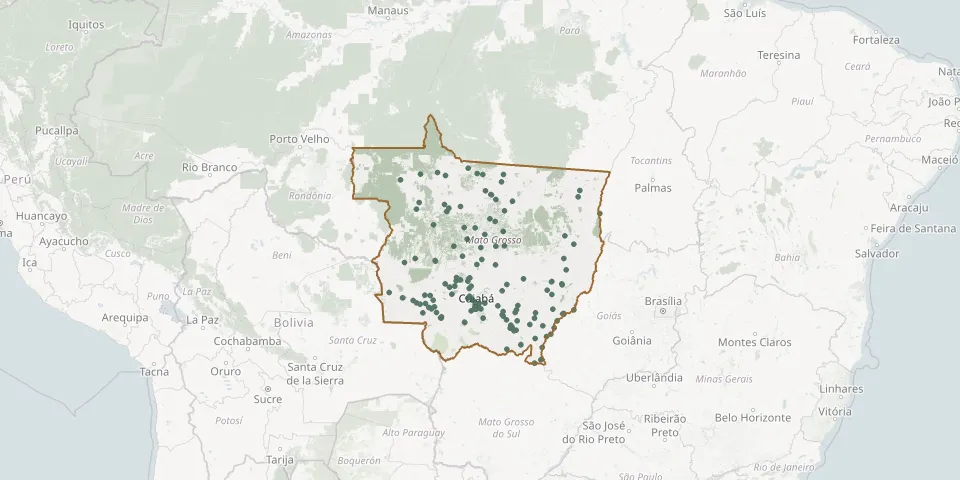 © OpenStreetMap
- Casa MortuáriaGPS coordinates: 14.54481° S, 52.80540° W
- Cemintério da Vila AuroraGPS coordinates: 16.47393° S, 54.61305° W
- Cimitério Parque Dos IpêsGPS coordinates: 15.89298° S, 52.28122° W
- Clarindo dos Santos CemeteryGPS coordinates: 17.39265° S, 54.76492° W
- Cláudia Municipal CemeteryGPS coordinates: 11.51253° S, 54.86863° W
- Cohab Velha CemeteryGPS coordinates: 16.27111° S, 56.62141° W
- Colíder Municipal CemeteryGPS coordinates: 10.79754° S, 55.47747° W
- Confresa Municipal CemeteryGPS coordinates: 10.63158° S, 51.56188° W
- Construmat CemeteryGPS coordinates: 15.63346° S, 56.10606° W
- Costa Verde Municipal CemeteryGPS coordinates: 15.67857° S, 56.12106° W
- Cotriguaçu Municipal CemeteryGPS coordinates: 9.91893° S, 58.56468° W
- Coxipó da Ponte CemeteryGPS coordinates: 15.61982° S, 56.06208° W
- Coxipó do Ouro CemeteryGPS coordinates: 15.45718° S, 55.98122° W
- Cristo Redentor CemeteryGPS coordinates: 14.62931° S, 52.35578° W
- Denise Municipal CemeteryGPS coordinates: 14.73299° S, 57.04960° W
- Deus é Amor Neighbourhood CemeteryGPS coordinates: 14.67504° S, 52.34377° W
- Diego Landim CemeteryGPS coordinates: 15.85056° S, 57.85521° W
- Feliz Natal Municipal CemeteryGPS coordinates: 12.39871° S, 54.93825° W
- Figueirópolis d'Oeste Municipal CemeteryGPS coordinates: 15.44536° S, 58.74030° W
- Frei João Jorge Municipal CemeteryGPS coordinates: 10.81635° S, 55.44826° W
- General Carneiro CemeteryGPS coordinates: 15.71469° S, 52.75600° W
- Green Park Municipal CemeteryGPS coordinates: 12.53047° S, 55.73186° W
- Guaranta do Norte Municipal CemeteryGPS coordinates: 9.94158° S, 54.91233° W
- Guarita CemeteryGPS coordinates: 15.59603° S, 56.15190° W
- Guiratinga CemeteryGPS coordinates: 16.35326° S, 53.75345° W
- Hope and Life Municipal Cemetery, Jardim das OrquídeasGPS coordinates: 13.80636° S, 56.08974° W
- Indiavaí Municipal CemeteryGPS coordinates: 15.49112° S, 58.57373° W
- Ipiranga do Norte Municipal CemeteryGPS coordinates: 12.24428° S, 56.16304° W
- Itanhangá Municipal CemeteryGPS coordinates: 12.21978° S, 56.64269° W
- Jaciara Municipal CemeteryGPS coordinates: 15.94573° S, 54.98080° W