
Paraná
683 known cemeteries in Paraná, Brazil.
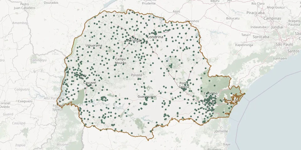 © OpenStreetMap
- Porto Internacional Municipal CemeteryGPS coordinates: 24.86952° S, 54.34440° W
- Porto Mendes CemeteryGPS coordinates: 24.47982° S, 54.29701° W
- Porto Rico Municipal CemeteryGPS coordinates: 22.78253° S, 53.27323° W
- Porto Ubá Municipal CemeteryGPS coordinates: 24.04606° S, 51.63064° W
- Prado Ferreira Municipal CemeteryGPS coordinates: 23.03163° S, 51.44989° W
- Pranchita Municipal CemeteryGPS coordinates: 26.02091° S, 53.74490° W
- Presidente Castelo Branco CemeteryGPS coordinates: 23.28320° S, 52.15492° W
- Primo Cruzado CemeteryGPS coordinates: 24.62226° S, 53.72150° W
- Prudentópolis Municipal CemeteryGPS coordinates: 25.20865° S, 50.97186° W
- Quarto Centenário Municipal CemeteryGPS coordinates: 24.28394° S, 53.07747° W
- Quatro Barras Municipal CemeteryGPS coordinates: 25.36701° S, 49.07905° W
- Quatro Marcos CemeteryGPS coordinates: 23.11639° S, 52.70561° W
- Quatro Pontes Municipal CemeteryGPS coordinates: 24.57978° S, 53.98027° W
- Quedas do Iguaçu Municipal CemeteryGPS coordinates: 25.45549° S, 52.90742° W
- Querência do Norte Municipal CemeteryGPS coordinates: 23.06879° S, 53.48734° W
- Quinta do Sol Municipal CemeteryGPS coordinates: 23.85811° S, 52.13062° W
- Quinzópolis Municipal CemeteryGPS coordinates: 23.03744° S, 50.57401° W
- Quitandinha Municipal CemeteryGPS coordinates: 25.86875° S, 49.49727° W
- Rafael Protzek Municipal Cemetery, Novo ItacolomiGPS coordinates: 23.76101° S, 51.50426° W
- Ramilândia Municipal CemeteryGPS coordinates: 25.11592° S, 54.03529° W
- Rancho Alegre d'Oeste Municipal CemeteryGPS coordinates: 24.31277° S, 52.95332° W
- Rancho Alegre Municipal CemeteryGPS coordinates: 23.05778° S, 50.90705° W
- Realeza Municipal CemeteryGPS coordinates: 25.77759° S, 53.53540° W
- Rebouças CemeteryGPS coordinates: 25.61243° S, 50.69107° W
- Recanto da Paz CemeteryGPS coordinates: 23.62104° S, 51.64413° W
- Recanto da Paz Municipal Cemetery, Santa Terezinha de ItaipuGPS coordinates: 25.43004° S, 54.39846° W
- Recanto da Saudade Cemetery, LeópolisGPS coordinates: 23.07974° S, 50.76034° W
- Renascença Municipal CemeteryGPS coordinates: 26.16264° S, 52.96294° W
- Reserva Municipal CemeteryGPS coordinates: 24.65429° S, 50.85731° W
- Retiro Cemetery, Sítio Cecília SamilaGPS coordinates: 25.76021° S, 49.28795° W