
Pirkanmaa
106 known cemeteries in Pirkanmaa, Finland.
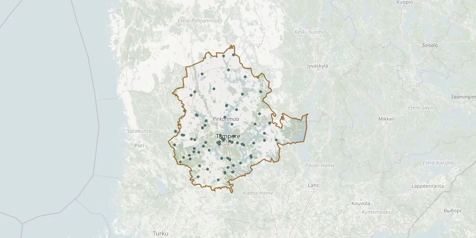 © OpenStreetMap
- Nokia CemeteryGPS coordinates: 61.47860° N, 23.53000° E
- Länsi-Teisko CemeteryGPS coordinates: 61.74730° N, 23.68880° E
- Valkeakoski Prayer House and CemeteryGPS coordinates: 61.26178° N, 24.03770° E
- Kangasala East CemeteryGPS coordinates: 61.45251° N, 24.10637° E
- Aitolahti CemeteryGPS coordinates: 61.54628° N, 23.88989° E
- Ikaalinen South CemeteryGPS coordinates: 61.76401° N, 23.07399° E
- Töyrynperä Heroes' CemeteryGPS coordinates: 62.39322° N, 23.88104° E
- Lauttakangas CemeteryGPS coordinates: 61.81263° N, 22.79509° E
- Halkivaha CemeteryGPS coordinates: 61.19635° N, 23.30595° E
- Pälkäne Old CemeteryGPS coordinates: 61.33826° N, 24.26894° E
- Pirkkala CemeteryGPS coordinates: 61.46030° N, 23.56780° E
- Hellänmäki Heroes' CemeteryGPS coordinates: 61.27177° N, 22.70145° E
- Kärppälä Heroes' CemeteryGPS coordinates: 61.37616° N, 23.11179° E
- Nokia CemeteryGPS coordinates: 61.47828° N, 23.53551° E
- Sammaljoki Heroes' CemeteryGPS coordinates: 61.23201° N, 23.13068° E
- Vatiala CemeteryGPS coordinates: 61.47509° N, 23.96966° E
- Kihniö CemeteryGPS coordinates: 62.19684° N, 23.19028° E
- Teisko Cemetery TampereGPS coordinates: 61.67333° N, 23.84824° E
- Ahrikkala CemeteryGPS coordinates: 61.70801° N, 23.27263° E
- Eräjärvi CemeteryGPS coordinates: 61.57692° N, 24.56490° E
- Halkivaha Heroes' CemeteryGPS coordinates: 61.19609° N, 23.30549° E
- Hämeenkyrö Church and Heroes' CemeteryGPS coordinates: 61.63522° N, 23.19300° E
- Hämeenkyrö Old CemeteryGPS coordinates: 61.63222° N, 23.19383° E
- Harju CemeteryGPS coordinates: 61.97522° N, 22.94321° E
- Harju CemeteryGPS coordinates: 61.50271° N, 23.65663° E
- Ikaalinen Heroes' CemeteryGPS coordinates: 61.77029° N, 23.06276° E
- Itä-Aure CemeteryGPS coordinates: 62.04144° N, 23.44901° E
- Itä-Aure Heroes' CemeteryGPS coordinates: 62.04157° N, 23.44766° E
- Juupajoen kirkonkylä Heroes' CemeteryGPS coordinates: 61.78196° N, 24.45933° E
- Kiikka CemeteryGPS coordinates: 61.32133° N, 22.77572° E