
Réunion
41 known cemeteries in Réunion, France.
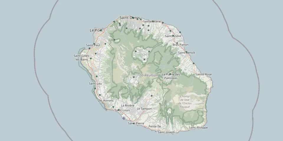 © OpenStreetMap
- Bel-Air CemeteryGPS coordinates: 20.90268° S, 55.60225° E
- Bellevue CemeteryGPS coordinates: 20.89708° S, 55.55559° E
- Bois de Nèfles CemeteryGPS coordinates: 20.99470° S, 55.33470° E
- Bras-Panon CemeteryGPS coordinates: 20.99121° S, 55.66874° E
- Brulé CemeteryGPS coordinates: 20.92662° S, 55.43333° E
- Cemetery of the Enslaved and the ForgottenGPS coordinates: 21.01428° S, 55.26036° E
- Champ Borne CemeteryGPS coordinates: 20.94440° S, 55.68230° E
- Cilaos CemeteryGPS coordinates: 21.13986° S, 55.46696° E
- Colimaçons CemeteryGPS coordinates: 21.13664° S, 55.29377° E
- Dos d'Âne CemeteryGPS coordinates: 20.97764° S, 55.37611° E
- Étang CemeteryGPS coordinates: 20.99538° S, 55.28214° E
- Etang salé les hauts CemeteryGPS coordinates: 21.27035° S, 55.37087° E
- Grand Ilet Landscaped CemeteryGPS coordinates: 21.02770° S, 55.47610° E
- Guillaume CemeteryGPS coordinates: 21.03731° S, 55.28930° E
- Hell-Bourg CemeteryGPS coordinates: 21.06273° S, 55.51608° E
- Intercommunal de Bois Rouge CemeteryGPS coordinates: 20.91633° S, 55.53535° E
- Jésuites CemeteryGPS coordinates: 20.93570° S, 55.53560° E
- La Bretagne CemeteryGPS coordinates: 20.92772° S, 55.49562° E
- La Plaine des Cafres CemeteryGPS coordinates: 21.22165° S, 55.55030° E
- La Plaine des Palmistes CemeteryGPS coordinates: 21.12625° S, 55.63625° E
- Lazaret CemeteryGPS coordinates: 20.89796° S, 55.37522° E
- Le Port Landscaped CemeteryGPS coordinates: 20.93615° S, 55.31208° E
- L'Est CemeteryGPS coordinates: 20.88207° S, 55.46416° E
- Old Lepers' CemeteryGPS coordinates: 20.90647° S, 55.40064° E
- Père-Lafosse CemeteryGPS coordinates: 21.28310° S, 55.39670° E
- Père Raimbault CemeteryGPS coordinates: 20.90645° S, 55.40065° E
- Piton st Leu CemeteryGPS coordinates: 21.21769° S, 55.30872° E
- Prima CemeteryGPS coordinates: 20.88788° S, 55.49909° E
- Quartier Français CemeteryGPS coordinates: 20.93816° S, 55.63744° E
- Rivière des pluies CemeteryGPS coordinates: 20.91304° S, 55.51065° E