
Zala
329 known cemeteries in Zala, Hungary.
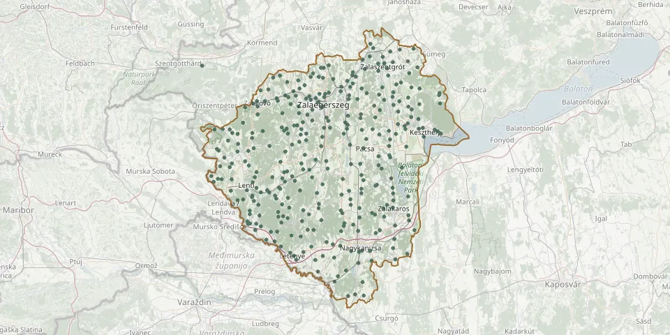 © OpenStreetMap
- Csörötnek CemeteryGPS coordinates: 46.94653° N, 16.36786° E
- Nagylengyel CemeteryGPS coordinates: 46.77569° N, 16.75855° E
- Nagykanizsa Public CemeteryGPS coordinates: 46.44747° N, 16.99763° E
- Galambok CemeteryGPS coordinates: 46.51530° N, 17.12750° E
- Kerecseny CemeteryGPS coordinates: 46.62278° N, 17.05111° E
- Gelsesziget CemeteryGPS coordinates: 46.56266° N, 16.98797° E
- Rám Cemetery, BabosdöbréteGPS coordinates: 46.79468° N, 16.76437° E
- Ormándlak CemeteryGPS coordinates: 46.76106° N, 16.75644° E
- Szentliszló CemeteryGPS coordinates: 46.57376° N, 16.82743° E
- Türjei Road Public Cemetery, ZalaszentgrótGPS coordinates: 46.95333° N, 17.08558° E
- Iborfia CemeteryGPS coordinates: 46.74165° N, 16.75053° E
- Gyenes CemeteryGPS coordinates: 46.77422° N, 17.28324° E
- Csáford CemeteryGPS coordinates: 46.93251° N, 17.06209° E
- Oltárc CemeteryGPS coordinates: 46.52990° N, 16.83781° E
- Pördefölde CemeteryGPS coordinates: 46.59030° N, 16.70582° E
- Vonyarcvashegy CemeteryGPS coordinates: 46.76363° N, 17.30844° E
- Árpád Street Cemetery, HévízGPS coordinates: 46.79111° N, 17.17703° E
- Orosztony CemeteryGPS coordinates: 46.62524° N, 17.05578° E
- Szentpál CemeteryGPS coordinates: 46.90742° N, 16.74684° E
- Alsóság Evangelical CemeteryGPS coordinates: 47.23590° N, 17.14040° E
- Göcseji út Cemetery, ZalaegerszegGPS coordinates: 46.83596° N, 16.83620° E
- Zalakaros CemeteryGPS coordinates: 46.56360° N, 17.11860° E
- Adorján CemeteryGPS coordinates: 46.54046° N, 16.68747° E
- Ady Endre utca Cemetery, ZalakomárGPS coordinates: 46.52923° N, 17.18263° E
- Akácfa Street Cemetery, ZalaegerszegGPS coordinates: 46.87379° N, 16.86701° E
- Alibánfa CemeteryGPS coordinates: 46.89014° N, 16.91594° E
- Almásháza CemeteryGPS coordinates: 46.83912° N, 17.04526° E
- Alsónemesapáti CemeteryGPS coordinates: 46.85708° N, 16.94482° E
- Alsópáhok Public CemeteryGPS coordinates: 46.77617° N, 17.16772° E
- Alsórajk CemeteryGPS coordinates: 46.65222° N, 16.99460° E