
Westmoreland
26 known cemeteries in Westmoreland, Jamaica.
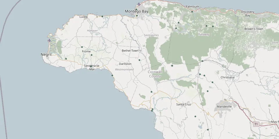 © OpenStreetMap
- Accompong CemeteryGPS coordinates: 18.22701° N, 77.75415° W
- Black River CemeteryGPS coordinates: 18.03150° N, 77.84694° W
- Blackwin CemeteryGPS coordinates: 18.39567° N, 77.73570° W
- Bushy Park CemeteryGPS coordinates: 18.11222° N, 77.58616° W
- Duanvale CemeteryGPS coordinates: 18.40637° N, 77.59170° W
- Georges Plain CemeteryGPS coordinates: 18.27547° N, 78.13498° W
- Holy Trinity Anglican Church CemeteryGPS coordinates: 18.31104° N, 78.18029° W
- Kinloss CemeteryGPS coordinates: 18.40425° N, 77.56165° W
- Lititz Moravian Church CemeteryGPS coordinates: 17.93881° N, 77.58557° W
- Martha Brae CemeteryGPS coordinates: 18.46989° N, 77.65992° W
- Mearnsville Methodist Church CemeteryGPS coordinates: 18.18313° N, 78.03685° W
- Mount Herman Anglican ChurchGPS coordinates: 17.99839° N, 77.64444° W
- Old Jewish Cemetery, Montego BayGPS coordinates: 18.47991° N, 77.92349° W
- Oxford CemeteryGPS coordinates: 18.18866° N, 77.62253° W
- Pyr River CemeteryGPS coordinates: 18.45219° N, 77.92039° W
- Sacred Heart Catholic ChurchGPS coordinates: 18.25247° N, 77.90852° W
- Saint George's Church CemeteryGPS coordinates: 18.15231° N, 77.56365° W
- Saint George's Memorial ParkGPS coordinates: 18.22363° N, 78.13830° W
- Saint Simon - Comfort Hall CemeteryGPS coordinates: 18.18290° N, 77.60210° W
- Sandy Bay CemeteryGPS coordinates: 18.44881° N, 78.08429° W
- Savanna-la-mar CemeteryGPS coordinates: 18.22409° N, 78.13694° W
- St John Anglican Church CemeteryGPS coordinates: 18.02420° N, 77.84943° W
- St Paul's Anglican Church CemeteryGPS coordinates: 18.25820° N, 78.25582° W
- St Silas Anglican Church CemeteryGPS coordinates: 18.24817° N, 77.61102° W
- Wakefield CemeteryGPS coordinates: 18.42115° N, 77.72386° W
- White Hall CemeteryGPS coordinates: 18.10930° N, 77.85180° W