
Saldus Municipality
45 known cemeteries in Saldus Municipality, Latvia.
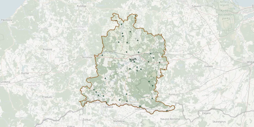 © OpenStreetMap
- German War Cemetery (World War II)GPS coordinates: 56.61026° N, 22.45940° E
- Čāpu CemeteryGPS coordinates: 56.43244° N, 22.35396° E
- Baļķi CemeteryGPS coordinates: 56.45549° N, 22.18574° E
- Bandzeri CemeteryGPS coordinates: 56.45929° N, 22.13286° E
- Bikstu CemeteryGPS coordinates: 56.76147° N, 22.43338° E
- Biļļu CemeteryGPS coordinates: 56.60856° N, 22.57589° E
- Blīdene CemeteryGPS coordinates: 56.64671° N, 22.76795° E
- Braku CemeteryGPS coordinates: 56.70560° N, 22.55148° E
- Bruzilas CemeteryGPS coordinates: 56.46582° N, 22.42558° E
- Čāpātāju CemeteryGPS coordinates: 56.65555° N, 22.47306° E
- Durbju CemeteryGPS coordinates: 56.79700° N, 22.38779° E
- Durbju Plague Victims' Mass GraveGPS coordinates: 56.79728° N, 22.38858° E
- Griezes CemeteryGPS coordinates: 56.41710° N, 22.21786° E
- Grīvaišu CemeteryGPS coordinates: 56.42531° N, 22.43006° E
- Jaunauce Brothers' CemeteryGPS coordinates: 56.44250° N, 22.69278° E
- Jaunlutriņi ChurchyardGPS coordinates: 56.81287° N, 22.38415° E
- Ķerkliņu CemeteryGPS coordinates: 56.51456° N, 22.69718° E
- Ķinguti CemeteryGPS coordinates: 56.88562° N, 22.31894° E
- Lejaskuncu CemeteryGPS coordinates: 56.82259° N, 22.46548° E
- Mazbišu CemeteryGPS coordinates: 56.70693° N, 22.42668° E
- Mīlestības kapsGPS coordinates: 56.66875° N, 22.51577° E
- Nīgrande CemeteryGPS coordinates: 56.49068° N, 22.08809° E
- Pidraišu CemeteryGPS coordinates: 56.68896° N, 22.17432° E
- Pilsblīdene CemeteryGPS coordinates: 56.69725° N, 22.67653° E
- Pilskalna Cemetery, LapsasGPS coordinates: 56.60000° N, 22.53556° E
- Podkalnu CemeteryGPS coordinates: 56.76285° N, 22.34444° E
- Priedula CemeteryGPS coordinates: 56.37111° N, 22.84694° E
- Purvakrogs Brothers' CemeteryGPS coordinates: 56.65133° N, 22.65407° E
- Purvkroga CemeteryGPS coordinates: 56.65139° N, 22.65417° E
- Rubas CemeteryGPS coordinates: 56.39557° N, 22.56352° E