
Grevenmacher
37 known cemeteries in Grevenmacher, Luxembourg.
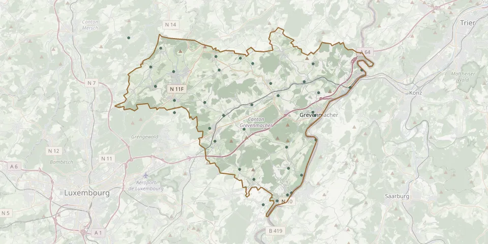 © OpenStreetMap
- Allënster CemeteryGPS coordinates: 49.72107° N, 6.21569° E
- Beidweiler CemeteryGPS coordinates: 49.73020° N, 6.30390° E
- Betzdorf CemeteryGPS coordinates: 49.68801° N, 6.35244° E
- Beyren CemeteryGPS coordinates: 49.63161° N, 6.33602° E
- Biwer CemeteryGPS coordinates: 49.70673° N, 6.37771° E
- Boudler CemeteryGPS coordinates: 49.72420° N, 6.35351° E
- Bourglinster CemeteryGPS coordinates: 49.70422° N, 6.22219° E
- Brouch CemeteryGPS coordinates: 49.72878° N, 6.33690° E
- Cemetery AhnGPS coordinates: 49.62660° N, 6.41940° E
- Cimitiére MertertGPS coordinates: 49.70307° N, 6.48589° E
- Eescheler CemeteryGPS coordinates: 49.71843° N, 6.30829° E
- Ehnen CemeteryGPS coordinates: 49.60404° N, 6.38648° E
- Ernster CemeteryGPS coordinates: 49.68123° N, 6.24775° E
- Fischbach CemeteryGPS coordinates: 49.74658° N, 6.18597° E
- Flaxweiler CemeteryGPS coordinates: 49.66680° N, 6.34180° E
- Godbrange CemeteryGPS coordinates: 49.73749° N, 6.22921° E
- Gonnerenger CemeteryGPS coordinates: 49.69194° N, 6.24781° E
- Gostingen CemeteryGPS coordinates: 49.62283° N, 6.35516° E
- Gréiwemaacher CemeteryGPS coordinates: 49.67879° N, 6.43786° E
- Gréiwemaacher Jewish CemeteryGPS coordinates: 49.68158° N, 6.43474° E
- Junglinster CemeteryGPS coordinates: 49.71711° N, 6.24660° E
- Lellig CemeteryGPS coordinates: 49.72387° N, 6.43490° E
- Lenningen CemeteryGPS coordinates: 49.60056° N, 6.36761° E
- Machtum CemeteryGPS coordinates: 49.65734° N, 6.43888° E
- Manternach CemeteryGPS coordinates: 49.70819° N, 6.42319° E
- Mensdorf CemeteryGPS coordinates: 49.65616° N, 6.30248° E
- Münschecker CemeteryGPS coordinates: 49.69853° N, 6.44252° E
- Niederdonven CemeteryGPS coordinates: 49.63246° N, 6.40185° E
- Oberdonven CemeteryGPS coordinates: 49.65104° N, 6.39938° E
- Ouljener CemeteryGPS coordinates: 49.67870° N, 6.31411° E