
Tlaxcala
61 known cemeteries in Tlaxcala, Mexico.
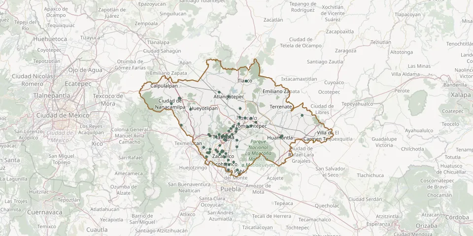 © OpenStreetMap
- San Francisco Tepeyanco Municipal CemeteryGPS coordinates: 19.24237° N, 98.24063° W
- San Gabriel CemeteryGPS coordinates: 19.30316° N, 98.23374° W
- San Gregorio Metepec CemeteryGPS coordinates: 19.27281° N, 98.25916° W
- San Hipólito Chimalpa Community CemeteryGPS coordinates: 19.31975° N, 98.24692° W
- San Jacinto CemeteryGPS coordinates: 19.14419° N, 98.16143° W
- San Jerónimo Zacualpan CemeteryGPS coordinates: 19.24059° N, 98.27219° W
- San Jorge Tezoquipan CemeteryGPS coordinates: 19.32282° N, 98.31323° W
- San José CemeteryGPS coordinates: 19.26294° N, 98.34846° W
- San Juan Huactzinco Municipal CemeteryGPS coordinates: 19.23921° N, 98.24855° W
- San Juan Totolac Municipal CemeteryGPS coordinates: 19.32998° N, 98.26253° W
- San Lorenzo Axocomanitla Municipal CemeteryGPS coordinates: 19.22689° N, 98.25873° W
- San Luis Apizaquito CemeteryGPS coordinates: 19.41854° N, 98.11798° W
- San Miguel Tlamahuco CemeteryGPS coordinates: 19.32457° N, 98.23984° W
- Santa Anita CemeteryGPS coordinates: 19.32424° N, 97.91180° W
- Santa Anita CemeteryGPS coordinates: 19.38747° N, 98.15404° W
- Santa Catarina Ayometla CemeteryGPS coordinates: 19.19617° N, 98.21148° W
- Santa María Texcalac CemeteryGPS coordinates: 19.41552° N, 98.08530° W
- Santiago Michac CemeteryGPS coordinates: 19.21346° N, 98.33279° W
- Santo Tomás de Cuahuixmatlac CemeteryGPS coordinates: 19.30098° N, 98.16405° W
- Teacalco Zenaida Ortega Díaz CemeteryGPS coordinates: 19.25342° N, 98.31404° W
- Tenancingo Municipal CemeteryGPS coordinates: 19.14373° N, 98.21139° W
- Tepeyanco Municipal CemeteryGPS coordinates: 19.24565° N, 98.24653° W
- Tizatlán CemeteryGPS coordinates: 19.34890° N, 98.20885° W
- Tlaltepango Neighbourhood CemeteryGPS coordinates: 19.12276° N, 98.15020° W
- Tlaxco Municipal CemeteryGPS coordinates: 19.61283° N, 98.11280° W
- Tzompantepec CemeteryGPS coordinates: 19.37655° N, 98.08448° W
- Unidad Habitacional II CemeteryGPS coordinates: 19.31802° N, 98.27986° W
- Venustiano Carranza Neighbourhood Municipal CemeteryGPS coordinates: 19.39600° N, 98.05765° W
- Xicohtzinco Municipal CemeteryGPS coordinates: 19.17563° N, 98.22706° W
- Xolalpan Municipal CemeteryGPS coordinates: 19.26617° N, 98.16416° W