
Lesser Poland Voivodeship
1,421 known cemeteries in Lesser Poland Voivodeship, Poland.
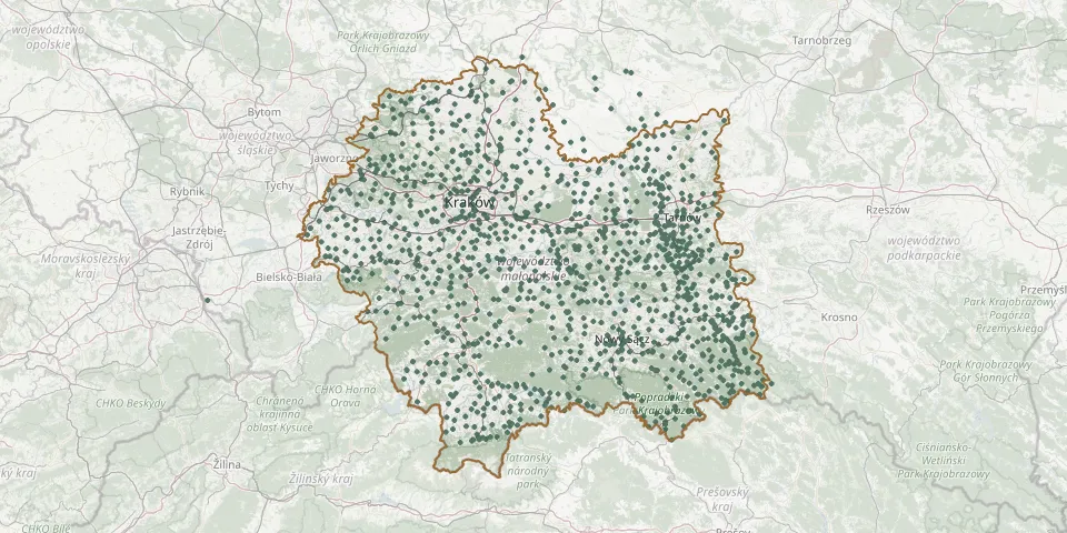 © OpenStreetMap
- Wisielce Cemetery, PrzysłopGPS coordinates: 49.46649° N, 20.47421° E
- Wiśniowa Parish CemeteryGPS coordinates: 49.78597° N, 20.12048° E
- Wiśniowa War Cemetery No. 373GPS coordinates: 49.77954° N, 20.10847° E
- Wiśniowa War Cemetery No. 374GPS coordinates: 49.77866° N, 20.11564° E
- Witanowice Parish CemeteryGPS coordinates: 49.91974° N, 19.54110° E
- Witkowice Parish CemeteryGPS coordinates: 49.91255° N, 19.27529° E
- Witów Parish CemeteryGPS coordinates: 49.32531° N, 19.81992° E
- Witów Parish CemeteryGPS coordinates: 50.15551° N, 20.57268° E
- Władysław Parish CemeteryGPS coordinates: 50.27168° N, 19.97389° E
- Włosań Parish CemeteryGPS coordinates: 49.91455° N, 19.90486° E
- Włosienica Parish CemeteryGPS coordinates: 50.01439° N, 19.31317° E
- Wodzislaw Parish CemeteryGPS coordinates: 50.51928° N, 20.19570° E
- Wojakowa Parish CemeteryGPS coordinates: 49.80266° N, 20.55830° E
- Wojkowa Lemko CemeteryGPS coordinates: 49.34444° N, 20.99462° E
- Wojkowa Parish CemeteryGPS coordinates: 49.34372° N, 20.99484° E
- Wojnicz Municipal CemeteryGPS coordinates: 49.95970° N, 20.84928° E
- Wojnicz War Cemetery No. 285GPS coordinates: 49.95992° N, 20.84832° E
- Wojnicz-Zamoście War Cemetery No. 282GPS coordinates: 49.95722° N, 20.82751° E
- Wójtowa New Parish CemeteryGPS coordinates: 49.69304° N, 21.28905° E
- Wójtowa Old Parish CemeteryGPS coordinates: 49.69344° N, 21.29125° E
- Wójtowa War Cemetery No. 102GPS coordinates: 49.69822° N, 21.31167° E
- Wola Batorska Parish CemeteryGPS coordinates: 50.05476° N, 20.28429° E
- Wola Batorska War Cemetery No. 324GPS coordinates: 50.04826° N, 20.26870° E
- Wola Dębińska Epidemic CemeteryGPS coordinates: 49.98683° N, 20.71187° E
- Wola Filipowska Parish CemeteryGPS coordinates: 50.13036° N, 19.58704° E
- Wola Mędrzechowska Parish CemeteryGPS coordinates: 50.26548° N, 21.01414° E
- Wola Nieszkowska-Wichras War Cemetery No. 340GPS coordinates: 49.88540° N, 20.37960° E
- Wola Nieszkowska-Wichras War Cemetery No. 341GPS coordinates: 49.88542° N, 20.37969° E
- Wola Piskulina Parish CemeteryGPS coordinates: 49.58172° N, 20.38451° E
- Wola Przemykowska Parish CemeteryGPS coordinates: 50.17365° N, 20.68365° E