
South Bačka District
104 known cemeteries in South Bačka District, Serbia.
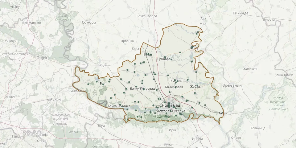 © OpenStreetMap
- Despotovo CemeteryGPS coordinates: 45.46325° N, 19.51912° E
- Donje CemeteryGPS coordinates: 45.19692° N, 19.93679° E
- Đurđevo CemeteryGPS coordinates: 45.33243° N, 20.05849° E
- Evangelical cemetery, SelenčaGPS coordinates: 45.41716° N, 19.29914° E
- Futog Central CemeteryGPS coordinates: 45.25437° N, 19.68735° E
- Futog Lower Old CemeteryGPS coordinates: 45.24007° N, 19.72770° E
- Futog Lower Orthodox CemeteryGPS coordinates: 45.24084° N, 19.72655° E
- Futog New CemeteryGPS coordinates: 45.24251° N, 19.71458° E
- Gajdobra CemeteryGPS coordinates: 45.35777° N, 19.44446° E
- Gložan CemeteryGPS coordinates: 45.27552° N, 19.55504° E
- Gospođinci CemeteryGPS coordinates: 45.41474° N, 19.99415° E
- Kać CemeteryGPS coordinates: 45.30919° N, 19.94678° E
- Kalos CemeteryGPS coordinates: 45.24789° N, 19.41049° E
- Karađorđevo CemeteryGPS coordinates: 45.30055° N, 19.31040° E
- Kisač CemeteryGPS coordinates: 45.35123° N, 19.71830° E
- Kovilj CemeteryGPS coordinates: 45.23996° N, 20.03373° E
- Kucura Hungarian-Rusyn CemeteryGPS coordinates: 45.51745° N, 19.57372° E
- Kucura Old Rusyn CemeteryGPS coordinates: 45.52367° N, 19.59844° E
- Kucura Serbian CemeteryGPS coordinates: 45.52520° N, 19.60493° E
- Kulpin Evangelical CemeteryGPS coordinates: 45.39204° N, 19.58889° E
- Kulpin Serbian Orthodox CemeteryGPS coordinates: 45.40943° N, 19.59150° E
- Ledinci CemeteryGPS coordinates: 45.20446° N, 19.80496° E
- Lug CemeteryGPS coordinates: 45.18351° N, 19.54653° E
- Maglić CemeteryGPS coordinates: 45.37189° N, 19.53544° E
- Nazarensko CemeteryGPS coordinates: 45.27059° N, 19.82682° E
- Neštin Catholic CemeteryGPS coordinates: 45.22816° N, 19.45681° E
- Nova Gajdobra CemeteryGPS coordinates: 45.33317° N, 19.42698° E
- Novi Sad Calvinist CemeteryGPS coordinates: 45.24503° N, 19.82842° E
- Novi Sad Catholic CemeteryGPS coordinates: 45.24762° N, 19.82854° E
- Novi Sad Evangelical CemeteryGPS coordinates: 45.24519° N, 19.82748° E