
Zhytomyr Oblast
457 known cemeteries in Zhytomyr Oblast, Ukraine.
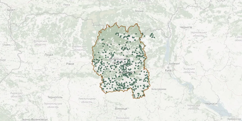 © OpenStreetMap
- Illinetske CemeteryGPS coordinates: 51.29740° N, 29.84481° E
- Irshanskyi CemeteryGPS coordinates: 50.72756° N, 29.45637° E
- Ivankiv CemeteryGPS coordinates: 50.14942° N, 28.88341° E
- Ivankiv CemeteryGPS coordinates: 50.40468° N, 28.56298° E
- Ivanopil CemeteryGPS coordinates: 49.83941° N, 28.23758° E
- Ivanopil Jewish CemeteryGPS coordinates: 49.87370° N, 28.20580° E
- Ivanopil Polish CemeteryGPS coordinates: 49.84728° N, 28.22814° E
- Ivnytsia Russian CemeteryGPS coordinates: 50.14273° N, 29.05688° E
- Ivnytsya Jewish CemeteryGPS coordinates: 50.14140° N, 29.04348° E
- Kalenske CemeteryGPS coordinates: 50.96595° N, 28.83940° E
- Kalynivka CemeteryGPS coordinates: 50.62035° N, 27.26449° E
- Kamianka CemeteryGPS coordinates: 50.81821° N, 28.12885° E
- Kamianka CemeteryGPS coordinates: 50.33551° N, 28.58919° E
- Kam'yanka Catholic CemeteryGPS coordinates: 50.93417° N, 29.09914° E
- Kamyanyi Brid Jewish CemeteryGPS coordinates: 50.41402° N, 27.83806° E
- Katerynivka CemeteryGPS coordinates: 49.99395° N, 28.57992° E
- Kharliivka CemeteryGPS coordinates: 49.94275° N, 29.31865° E
- Khehevald German Military CemeteryGPS coordinates: 50.22800° N, 28.66966° E
- Khmelyshche CemeteryGPS coordinates: 49.94007° N, 28.75630° E
- Khoroshiv CemeteryGPS coordinates: 50.57889° N, 28.43526° E
- Khoroshiv Jewish CemeteryGPS coordinates: 50.60061° N, 28.43466° E
- Khoroshiv Polish and Orthodox CemeteryGPS coordinates: 50.58905° N, 28.44949° E
- Klitnianskyi CemeteryGPS coordinates: 50.84477° N, 29.42241° E
- Klityshche CemeteryGPS coordinates: 50.43448° N, 28.56185° E
- Klocheve CemeteryGPS coordinates: 51.00460° N, 28.52847° E
- Kmytiv CemeteryGPS coordinates: 50.29197° N, 28.89562° E
- Kocheriv CemeteryGPS coordinates: 50.35047° N, 29.35078° E
- Kolodianka CemeteryGPS coordinates: 50.43877° N, 27.49498° E
- Kolodiazhne CemeteryGPS coordinates: 50.07167° N, 27.69557° E
- Kolodiivka CemeteryGPS coordinates: 50.38175° N, 28.39018° E