
Gwynedd
142 known cemeteries in Gwynedd, United Kingdom.
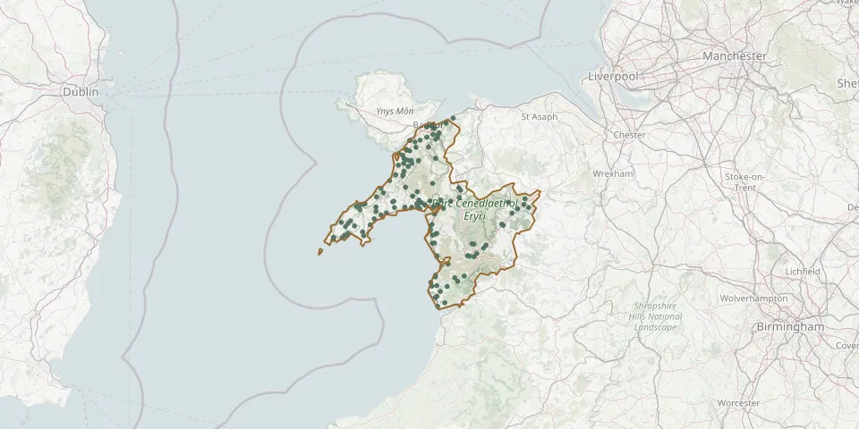 © OpenStreetMap
- Mynwent Pentir CemeteryGPS coordinates: 53.18210° N, 4.13726° W
- Mynwent Pentreuchaf CemeteryGPS coordinates: 52.92438° N, 4.44925° W
- Mynwent PwllheliGPS coordinates: 52.85161° N, 4.63569° W
- Mynwent PwllheliGPS coordinates: 52.87241° N, 4.60701° W
- Mynwent TanysgafellGPS coordinates: 53.17953° N, 4.07286° W
- Mynwent y PandyGPS coordinates: 52.85538° N, 3.66829° W
- Nefyn CemeteryGPS coordinates: 52.92560° N, 4.56803° W
- Nefyn CemeteryGPS coordinates: 52.91393° N, 4.54803° W
- Nefyn New CemeteryGPS coordinates: 52.93412° N, 4.52735° W
- Penamser CemeteryGPS coordinates: 52.93053° N, 4.14850° W
- Penrhyndeudraeth (Nazareth) Calvin Methodist CemeteryGPS coordinates: 52.93231° N, 4.07053° W
- Pentrefelin Congregational ChapelyardGPS coordinates: 52.93666° N, 4.19938° W
- Pontllyfni CemeteryGPS coordinates: 53.04349° N, 4.32862° W
- Prenteg CemeteryGPS coordinates: 52.94669° N, 4.11804° W
- Pwllheli Borough CemeteryGPS coordinates: 52.89426° N, 4.41863° W
- Pwllheli Polish CemeteryGPS coordinates: 52.89491° N, 4.41905° W
- Rehoboth CemeteryGPS coordinates: 52.85967° N, 4.10499° W
- Rhiw CemeteryGPS coordinates: 52.81903° N, 4.63959° W
- Rhiw CemeteryGPS coordinates: 52.81787° N, 4.63169° W
- Rhiw CemeteryGPS coordinates: 52.82612° N, 4.62238° W
- Rhosgadfan Calvanistic Methodist CemeteryGPS coordinates: 53.09667° N, 4.23082° W
- Rhydymain CemeteryGPS coordinates: 52.78325° N, 3.77441° W
- Saint Enddwyn ChurchyardGPS coordinates: 52.78979° N, 4.10348° W
- Saint Mary ChurchyardGPS coordinates: 52.84014° N, 4.11359° W
- Saint Mary ChurchyardGPS coordinates: 53.01103° N, 4.10176° W
- Saint Mary's ChurchGPS coordinates: 52.66700° N, 3.90814° W
- Saint Mary's ChurchyardGPS coordinates: 53.19161° N, 4.09911° W
- Saint Tanwgs ChurchGPS coordinates: 52.85796° N, 4.10774° W
- Saint Tecwyn's ChurchyardGPS coordinates: 52.91859° N, 4.03567° W
- Sarnau CemeteryGPS coordinates: 52.95409° N, 3.53305° W