
0
documented records
≈ 550–1,100
approx. capacity (graves)
0.027 km²
cemetery area
Oct 18, 2026
last modified
About this cemetery
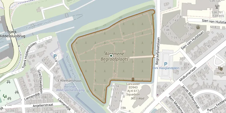
Harlingen's Jewish cemetery occupies a separate part of the municipal general cemetery on the Begraafplaatslaan. It has been in use since 1870 and was extended in 1909; its cast-iron fence from 1909 is a national monument. Before that the dead were buried at the Willemskade, and in 1953 that old cemetery was cleared, with the remains and gravestones moved to the new site.
Cemetery location
GPS coordinates: 53.178550° N, 5.423110° E Directions in Google Maps (opens in a new tab)
Memorials
No records yet
Photograph a headstone and add it to the archive.
Looking for someone who isn't listed? Request a photo.
Nearby cemeteries
The closest other burial grounds listed on EveryStone.
- Harlingen General Cemetery 120 m away · Harlingen
- Harlingen Roman Catholic Cemetery 840 m away · Harlingen
- Midlum Churchyard 1.7 km away · Midlum
- Wijnaldum Cemetery 3.1 km away · Wijnaldum
- Kimswerd Protestant Churchyard 4.3 km away · Kimswerd · 23 records
- Herbaijum Cemetery 4.9 km away · Herbaijum
- St. Gertudiskerk Churchyard 5.3 km away · Achlum
- Sexbierum Churchyard 6.1 km away · Sexbierum
- Arum St. Lambert Church Cemetery 6.8 km away · Arum
- Victoriustjerke Penjum Cemetery 7.1 km away · Pingjum
Contribute with the app
Our website works smoothly on both desktop and mobile devices. Prefer a native app? Check it out below.
- Capture clear headstone photos
- Save GPS grave locations automatically
- Transcribe inscriptions with our AI
- Suggest corrections to existing records
Common questions
How big is Harlingen Jewish Cemetery?
Harlingen Jewish Cemetery covers about 27,000 m² (6.7 acres), about the size of 4 soccer fields. It is the 9th largest of the 369 cemeteries we list in Friesland.