
West Flanders
503 known cemeteries in West Flanders, Belgium.
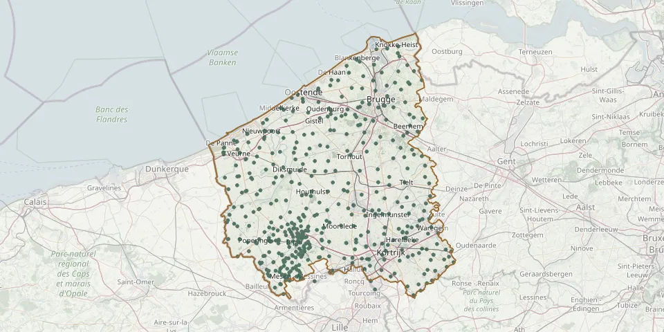 © OpenStreetMap
- Heist CemeteryGPS coordinates: 51.33405° N, 3.25079° E
- Knokke Communal Cemetery OldGPS coordinates: 51.33895° N, 3.29474° E
- Izegem Communal CemeteryGPS coordinates: 50.92089° N, 3.20453° E
- Centrum Knokke Heist CemeteryGPS coordinates: 51.32271° N, 3.29322° E
- Westkapelle Old ChurchyardGPS coordinates: 51.31484° N, 3.29948° E
- Emelgem Sint Pieter CemeteryGPS coordinates: 50.92175° N, 3.23183° E
- Emelgem Reperstraat CemeteryGPS coordinates: 50.93137° N, 3.21826° E
- Kachtem CemeteryGPS coordinates: 50.93089° N, 3.19174° E
- Torhout Old CemeteryGPS coordinates: 51.06919° N, 3.10552° E
- Roeselaarsestraat CemeteryGPS coordinates: 50.92177° N, 3.20442° E
- Sint-Jacob-de-Meerdere Cemetery, DammeGPS coordinates: 51.29262° N, 3.33077° E
- Torhout Communal CemeteryGPS coordinates: 51.07959° N, 3.09220° E
- Houthulst Belgian Military CemeteryGPS coordinates: 50.96653° N, 2.94844° E
- Brugge Assebroek Central CemeteryGPS coordinates: 51.19282° N, 3.23683° E
- BE-war Dickebusch New Military CemeteryGPS coordinates: 50.81832° N, 2.83291° E
- Moorslede Communal CemeteryGPS coordinates: 50.89289° N, 3.06769° E
- Brugge St. Peter's CemeteryGPS coordinates: 51.22927° N, 3.20473° E
- Ramskapelle Belgian Military CemeteryGPS coordinates: 51.11400° N, 2.76405° E
- Sint Martinuskerk, SijseleGPS coordinates: 51.20074° N, 3.32252° E
- Westhof Farm CemeteryGPS coordinates: 50.73725° N, 2.80559° E
- BE-war Steenkerke Belgian Military CemeteryGPS coordinates: 51.05913° N, 2.69048° E
- Elzenwalle Brasserie CemeteryGPS coordinates: 50.81084° N, 2.85944° E
- Hedge Row Trench CemeteryGPS coordinates: 50.81940° N, 2.91375° E
- Langemark German Military CemeteryGPS coordinates: 50.91987° N, 2.91678° E
- Vlamertinghe New Military CemeteryGPS coordinates: 50.84803° N, 2.81903° E
- Aalbeke Communal CemeteryGPS coordinates: 50.78116° N, 3.22826° E
- Aarsele Municipal CemeteryGPS coordinates: 50.99842° N, 3.41789° E
- Aartrijke CemeteryGPS coordinates: 51.12154° N, 3.09011° E
- Abeele Aerodrome Military CemeteryGPS coordinates: 50.81522° N, 2.65705° E
- Adinkerke Belgian Military CemeteryGPS coordinates: 51.07518° N, 2.60034° E