
Paraná
683 known cemeteries in Paraná, Brazil.
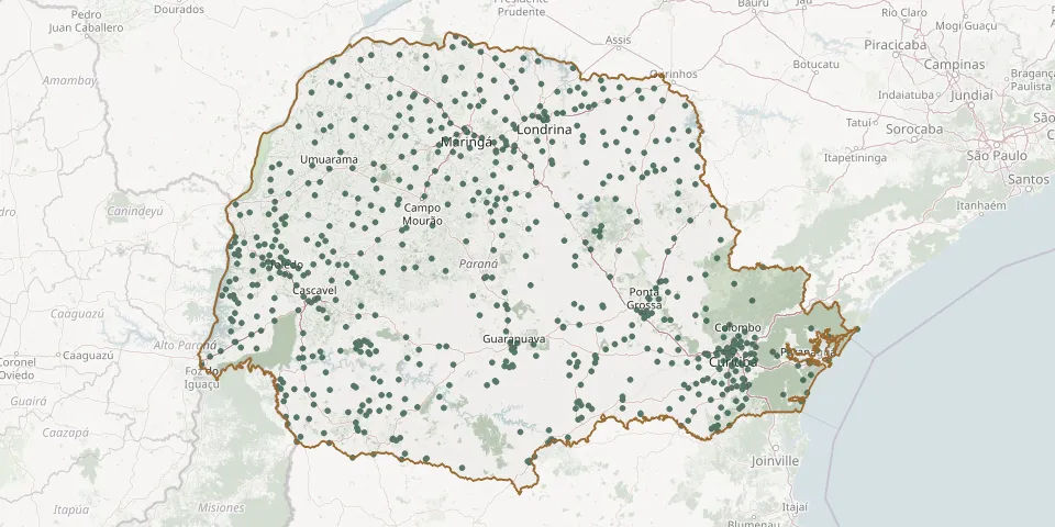 © OpenStreetMap
- São Pedro CemeteryGPS coordinates: 23.31825° S, 51.16017° W
- São Pedro do Iguaçu Municipal CemeteryGPS coordinates: 24.94974° S, 53.85927° W
- São Roque CemeteryGPS coordinates: 24.70428° S, 54.07566° W
- São Roque CemeteryGPS coordinates: 24.99641° S, 54.22170° W
- São Roque CemeteryGPS coordinates: 25.45418° S, 49.09673° W
- São Sebastião CemeteryGPS coordinates: 25.61346° S, 49.24881° W
- São Sebastião CemeteryGPS coordinates: 25.08284° S, 50.19162° W
- São Sebastião da Amoreira CemeteryGPS coordinates: 23.47146° S, 50.77339° W
- São Sebastião do Porto de Cima Municipal CemeteryGPS coordinates: 25.43615° S, 48.87826° W
- São Sebastião do Rio do Couro CemeteryGPS coordinates: 25.46151° S, 50.86386° W
- São Silvestre Rural CemeteryGPS coordinates: 25.10707° S, 49.65055° W
- São Valério CemeteryGPS coordinates: 25.77470° S, 53.66257° W
- São Vicente CemeteryGPS coordinates: 24.04872° S, 52.61319° W
- Sapopema Municipal CemeteryGPS coordinates: 23.90595° S, 50.57533° W
- Sarandi Municipal CemeteryGPS coordinates: 23.46687° S, 51.86124° W
- Saudade CemeteryGPS coordinates: 23.55680° S, 51.45916° W
- Saudade do Iguaçu Municipal CemeteryGPS coordinates: 25.68644° S, 52.61674° W
- Saudade Garden Municipal Cemetery (Antonio Faville), AdrianópolisGPS coordinates: 24.66794° S, 48.97730° W
- Saudade Garden Municipal Cemetery, ClevelândiaGPS coordinates: 26.39475° S, 52.33934° W
- Seção Progresso CemeteryGPS coordinates: 26.00808° S, 52.94279° W
- Sede Alvorada District CemeteryGPS coordinates: 24.83310° S, 53.63829° W
- Sengés Municipal CemeteryGPS coordinates: 24.11057° S, 49.47303° W
- Senhor Bom Jesus Cemetery, PiraquaraGPS coordinates: 25.45690° S, 49.06649° W
- Senhor Bom Jesus Cemetery, Sítio Antônio A. PereiraGPS coordinates: 25.93993° S, 49.39414° W
- Senhor Bom Jesus Chapel Cemetery, Colônia TimbotuvaGPS coordinates: 25.45071° S, 49.44077° W
- Sertaneja Municipal CemeteryGPS coordinates: 23.02597° S, 50.82751° W
- Sertanópolis Municipal CemeteryGPS coordinates: 23.06437° S, 51.03254° W
- Siqueira Campos Municipal CemeteryGPS coordinates: 23.68955° S, 49.83730° W
- Sítio Nilo Buml e Irmãos Chapel CemeteryGPS coordinates: 26.12867° S, 49.48799° W
- Socavão CemeteryGPS coordinates: 24.77286° S, 49.70630° W