
Paraná
683 known cemeteries in Paraná, Brazil.
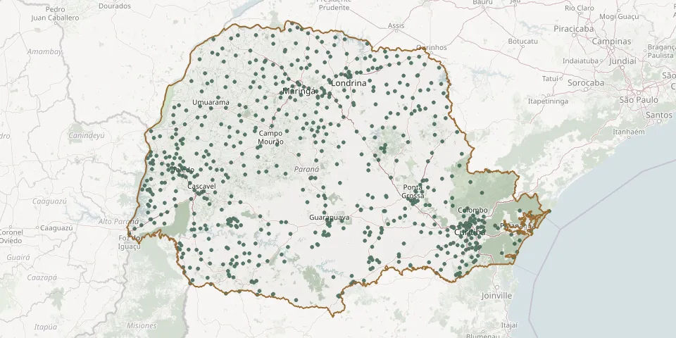 © OpenStreetMap
- Socorro CemeteryGPS coordinates: 25.56644° S, 51.55988° W
- Souls' CemeteryGPS coordinates: 25.31224° S, 49.82500° W
- Tabatinga CemeteryGPS coordinates: 25.85896° S, 49.14633° W
- Tamboara Municipal CemeteryGPS coordinates: 23.20707° S, 52.50608° W
- Tapejara Municipal CemeteryGPS coordinates: 23.72429° S, 52.86659° W
- Tapira Municipal CemeteryGPS coordinates: 23.31886° S, 53.06296° W
- Teixeira Soares Municipal CemeteryGPS coordinates: 25.36786° S, 50.45698° W
- Telêmaco Borba CemeteryGPS coordinates: 24.34151° S, 50.65622° W
- Telêmaco Borba Municipal CemeteryGPS coordinates: 24.33938° S, 50.60866° W
- Terra Boa Municipal CemeteryGPS coordinates: 23.76253° S, 52.45028° W
- Terra Rica Municipal CemeteryGPS coordinates: 22.72282° S, 52.61066° W
- Terra Roxa Municipal CemeteryGPS coordinates: 24.16925° S, 54.10701° W
- Tibagi Municipal CemeteryGPS coordinates: 24.51643° S, 50.41524° W
- Tijucas do Sul Municipal CemeteryGPS coordinates: 25.92542° S, 49.18044° W
- Toledo Municipal Cemetery (Cristo Rei)GPS coordinates: 24.73327° S, 53.75696° W
- Tomazina Municipal CemeteryGPS coordinates: 23.77422° S, 49.96422° W
- Três Barras do Paraná Municipal CemeteryGPS coordinates: 25.42671° S, 53.19900° W
- Três Bocas CemeteryGPS coordinates: 24.66328° S, 53.81490° W
- Três Irmãs Village CemeteryGPS coordinates: 24.44351° S, 54.25280° W
- Três Lagoas Municipal CemeteryGPS coordinates: 25.48057° S, 54.50431° W
- Tronco CemeteryGPS coordinates: 24.85984° S, 50.04550° W
- Tunas do Paraná Municipal CemeteryGPS coordinates: 24.97370° S, 49.08493° W
- Tuneiras do Oeste Municipal CemeteryGPS coordinates: 23.87245° S, 52.87161° W
- Turvo Municipal CemeteryGPS coordinates: 25.05010° S, 51.53051° W
- Ubaúna Municipal CemeteryGPS coordinates: 23.97700° S, 51.71649° W
- Ubiratã CemeteryGPS coordinates: 24.54465° S, 52.99869° W
- Ucraniano Esperamos Ressurreição CemeteryGPS coordinates: 25.21790° S, 50.97403° W
- Umbará Parish CemeteryGPS coordinates: 25.56654° S, 49.28392° W
- Umuarama Municipal CemeteryGPS coordinates: 23.77288° S, 53.31114° W
- União 1 Garden CemeteryGPS coordinates: 23.19282° S, 51.81826° W