
Paraná
683 known cemeteries in Paraná, Brazil.
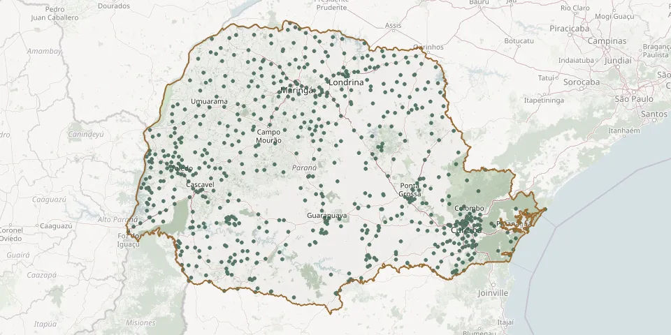 © OpenStreetMap
- Cristo Rei CemeteryGPS coordinates: 23.57104° S, 51.45927° W
- Cristo Rei CemeteryGPS coordinates: 22.75532° S, 51.37238° W
- Cristo Rei Municipal CemeteryGPS coordinates: 24.89686° S, 51.56061° W
- Cristo Rei Municipal CemeteryGPS coordinates: 23.86927° S, 51.85058° W
- Cruzeiro do Norte District CemeteryGPS coordinates: 23.22516° S, 50.85612° W
- Cruzeiro do Oeste Municipal CemeteryGPS coordinates: 23.76396° S, 53.07951° W
- Cruzeiro do Sul Municipal CemeteryGPS coordinates: 22.95864° S, 52.16080° W
- Cruzmaltina Municipal CemeteryGPS coordinates: 23.99578° S, 51.44369° W
- Cubatão CemeteryGPS coordinates: 25.82440° S, 48.77098° W
- Curitiba Jewish CemeteryGPS coordinates: 25.45412° S, 49.28440° W
- Curitiba Lutheran CemeteryGPS coordinates: 25.42014° S, 49.26287° W
- Curiúva Municipal CemeteryGPS coordinates: 24.04616° S, 50.45082° W
- Deodoro da Fonseca Cemetery, Piraí do SulGPS coordinates: 24.40859° S, 49.86283° W
- Dez de Maio CemeteryGPS coordinates: 24.68102° S, 53.91410° W
- Diamante d'Oeste Municipal CemeteryGPS coordinates: 24.93288° S, 54.09966° W
- Dinizópolis CemeteryGPS coordinates: 24.04272° S, 51.55202° W
- Distrito de Congonhas CemeteryGPS coordinates: 23.20534° S, 50.71677° W
- Divisor CemeteryGPS coordinates: 25.98015° S, 53.12236° W
- Doce Grande Municipal CemeteryGPS coordinates: 26.02611° S, 49.43268° W
- Dois Irmãos Municipal CemeteryGPS coordinates: 25.82698° S, 52.79013° W
- Dois Irmãos/Pr Municipal CemeteryGPS coordinates: 24.62122° S, 53.92330° W
- Dom Luis Bernetti Municipal Cemetery, AmpéreGPS coordinates: 25.91033° S, 53.46683° W
- Douradina Municipal CemeteryGPS coordinates: 23.38366° S, 53.29773° W
- Dr. Camargo CemeteryGPS coordinates: 23.55254° S, 52.21403° W
- Duas Colony CemeteryGPS coordinates: 25.92086° S, 50.71876° W
- Engenheiro Beltrão Municipal CemeteryGPS coordinates: 23.79087° S, 52.25295° W
- Esperança Nova Municipal CemeteryGPS coordinates: 23.72732° S, 53.81164° W
- Espigão Alto do Iguaçu Municipal CemeteryGPS coordinates: 25.43148° S, 52.84318° W
- Esquina Céu Azul CemeteryGPS coordinates: 24.93289° S, 54.30278° W
- Estrada Municipal Azelino Dala Costa Cemetery, Pato BrancoGPS coordinates: 26.21070° S, 52.60194° W