
Santa Catarina
1,559 known cemeteries in Santa Catarina, Brazil.
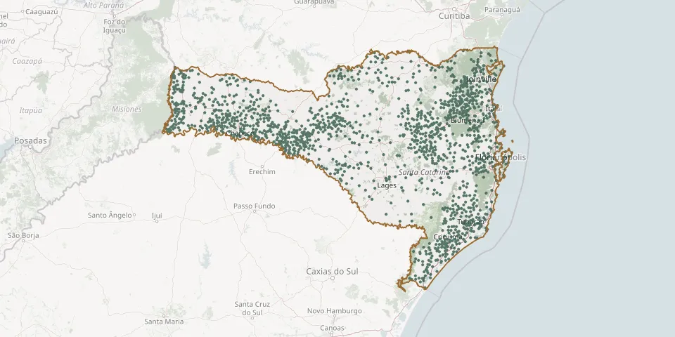 © OpenStreetMap
- 13 de Maio Baixo Cemetery, MassarandubaGPS coordinates: 26.65931° S, 49.03012° W
- Abdon Batista Municipal CemeteryGPS coordinates: 27.61942° S, 51.02347° W
- Abelardo Luz Municipal CemeteryGPS coordinates: 26.57524° S, 52.33921° W
- Adolfo Konder Catholic CemeteryGPS coordinates: 27.21320° S, 52.22101° W
- Adolfo Konder CemeteryGPS coordinates: 26.73509° S, 51.03804° W
- Adventista CemeteryGPS coordinates: 26.77160° S, 49.40375° W
- Agrolândia Municipal CemeteryGPS coordinates: 27.40297° S, 49.82303° W
- Agronômica Municipal CemeteryGPS coordinates: 27.26702° S, 49.71217° W
- Água Amarela CemeteryGPS coordinates: 27.16785° S, 52.57070° W
- Águas Belas CemeteryGPS coordinates: 27.13856° S, 51.72965° W
- Águas Brancas CemeteryGPS coordinates: 27.95812° S, 49.58408° W
- Águas Mornas Central CemeteryGPS coordinates: 27.69517° S, 48.82196° W
- Águas Mornas Closed CemeteryGPS coordinates: 27.72618° S, 48.97888° W
- Águas Mornas Lutheran Cemetery (IECLB)GPS coordinates: 27.74898° S, 48.92798° W
- Águas Mornas Municipal CemeteryGPS coordinates: 28.13714° S, 48.76794° W
- Águas Negras Cemetery, BotuveráGPS coordinates: 27.20310° S, 49.02904° W
- Aguinhas CemeteryGPS coordinates: 26.99665° S, 52.97780° W
- Aiurê Parish CemeteryGPS coordinates: 28.11173° S, 49.29512° W
- Alfredo Scottini School Cemetery, Rio do OesteGPS coordinates: 27.12467° S, 49.87005° W
- Alfredo Wagner CemeteryGPS coordinates: 27.73431° S, 49.38458° W
- Alfredo Wagner CemeteryGPS coordinates: 27.64850° S, 49.30255° W
- Alfredo Wagner Municipal CemeteryGPS coordinates: 27.69973° S, 49.33736° W
- Alto Águas Verdes Community Cemetery, Rio do OesteGPS coordinates: 27.22113° S, 49.87298° W
- Alto Barragem CemeteryGPS coordinates: 27.11144° S, 49.47980° W
- Alto Baú Catholic Cemetery, IlhotaGPS coordinates: 26.82243° S, 48.95491° W
- Alto Bela Vista CemeteryGPS coordinates: 27.44453° S, 51.93467° W
- Alto Bela Vista Municipal CemeteryGPS coordinates: 27.42753° S, 51.91948° W
- Alto Biguaçu CemeteryGPS coordinates: 27.49457° S, 48.72899° W
- Alto Braço Cemetery, Leoberto LealGPS coordinates: 27.50475° S, 49.28612° W
- Alto Cambuim CemeteryGPS coordinates: 26.98453° S, 52.80242° W