
Antioquia
117 known cemeteries in Antioquia, Colombia.
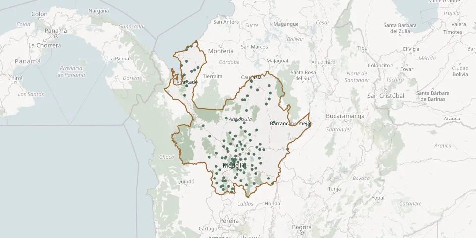 © OpenStreetMap
- Abejorral CemeteryGPS coordinates: 5.79487° N, 75.43062° W
- Alejandría CemeteryGPS coordinates: 6.37968° N, 75.14223° W
- Amalfi Municipal CemeteryGPS coordinates: 6.91154° N, 75.08521° W
- Andes Municipal CemeteryGPS coordinates: 5.66209° N, 75.87740° W
- Angostura CemeteryGPS coordinates: 6.88210° N, 75.33495° W
- Anzá CemeteryGPS coordinates: 6.30541° N, 75.85256° W
- Apartadó Parish CemeteryGPS coordinates: 7.88623° N, 76.63189° W
- Aragón CemeteryGPS coordinates: 6.78085° N, 75.55942° W
- Arboletes CemeteryGPS coordinates: 8.85132° N, 76.42893° W
- Argelia CemeteryGPS coordinates: 5.73042° N, 75.13737° W
- Armenia Municipal CemeteryGPS coordinates: 6.15374° N, 75.78744° W
- Barrio Zona Industrial CemeteryGPS coordinates: 7.67990° N, 76.67748° W
- Belén CemeteryGPS coordinates: 6.23615° N, 75.59966° W
- Betania CemeteryGPS coordinates: 5.74284° N, 75.97180° W
- Betulia CemeteryGPS coordinates: 6.11703° N, 75.98362° W
- Briceño Municipal CemeteryGPS coordinates: 7.11622° N, 75.54986° W
- Buenos Aires CemeteryGPS coordinates: 5.68314° N, 75.83750° W
- Cáceres CemeteryGPS coordinates: 7.58004° N, 75.34617° W
- Caicedo CemeteryGPS coordinates: 6.40469° N, 75.98085° W
- Caldas Municipal CemeteryGPS coordinates: 6.08578° N, 75.63567° W
- Campos de Paz CemeteryGPS coordinates: 6.20499° N, 75.59087° W
- Caramanta CemeteryGPS coordinates: 5.54704° N, 75.64679° W
- Cedeño CemeteryGPS coordinates: 7.06968° N, 75.35735° W
- Charrascal CemeteryGPS coordinates: 6.29742° N, 75.78597° W
- Cisneros CemeteryGPS coordinates: 6.53863° N, 75.07930° W
- Ciudad Bolívar Municipal CemeteryGPS coordinates: 5.85000° N, 76.01726° W
- Cocorná CemeteryGPS coordinates: 6.05241° N, 75.18245° W
- Concepción Municipal CemeteryGPS coordinates: 6.39711° N, 75.25846° W
- Concordia CemeteryGPS coordinates: 6.04180° N, 75.90430° W
- Cristales CemeteryGPS coordinates: 6.48242° N, 74.92800° W