
Saarland
437 known cemeteries in Saarland, Germany.
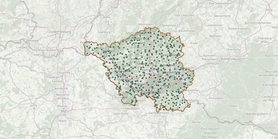 © OpenStreetMap
- Bergweiler CemeteryGPS coordinates: 49.47360° N, 7.00154° E
- Berschweiler CemeteryGPS coordinates: 49.43363° N, 7.02644° E
- Berus CemeteryGPS coordinates: 49.27111° N, 6.67660° E
- Berus CemeteryGPS coordinates: 49.26446° N, 6.69238° E
- Beschberg CemeteryGPS coordinates: 49.20792° N, 7.05648° E
- Besseringen CemeteryGPS coordinates: 49.47991° N, 6.60665° E
- Bethingen CemeteryGPS coordinates: 49.45882° N, 6.53636° E
- Bettingen CemeteryGPS coordinates: 49.44360° N, 6.85809° E
- Bexbach Central CemeteryGPS coordinates: 49.35140° N, 7.26128° E
- Bierbach an der Blies CemeteryGPS coordinates: 49.26255° N, 7.27504° E
- Bierfeld CemeteryGPS coordinates: 49.60639° N, 6.94339° E
- Biesingen CemeteryGPS coordinates: 49.21865° N, 7.20221° E
- Bietzen CemeteryGPS coordinates: 49.41791° N, 6.65442° E
- Bildstock CemeteryGPS coordinates: 49.33451° N, 7.08029° E
- Bilsdorf CemeteryGPS coordinates: 49.38270° N, 6.82324° E
- Biringen CemeteryGPS coordinates: 49.41274° N, 6.55056° E
- Bischmisheim CemeteryGPS coordinates: 49.21710° N, 7.06950° E
- Bisten Old CemeteryGPS coordinates: 49.25379° N, 6.70610° E
- Bisten Woodland CemeteryGPS coordinates: 49.25857° N, 6.69574° E
- Blickweiler CemeteryGPS coordinates: 49.21390° N, 7.24583° E
- Bliesdalheim CemeteryGPS coordinates: 49.17157° N, 7.23735° E
- Bliesen CemeteryGPS coordinates: 49.49614° N, 7.10162° E
- Blieskastel Cemetery of HonourGPS coordinates: 49.23637° N, 7.25435° E
- Blieskastel Jewish CemeteryGPS coordinates: 49.24091° N, 7.25419° E
- Blieskastel Monastery CemeteryGPS coordinates: 49.24137° N, 7.25773° E
- Bliesmengen-Bolchen CemeteryGPS coordinates: 49.14630° N, 7.11181° E
- Bliesmengen – Bolchen War CemeteryGPS coordinates: 49.14797° N, 7.12559° E
- Bliesransbach CemeteryGPS coordinates: 49.16438° N, 7.09272° E
- Böckweiler CemeteryGPS coordinates: 49.18638° N, 7.29139° E
- Borg CemeteryGPS coordinates: 49.49734° N, 6.43786° E