
Thuringia
2,006 known cemeteries in Thuringia, Germany.
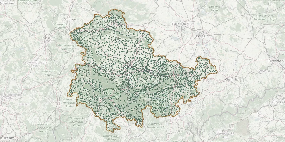 © OpenStreetMap
- Wöhlsdorf Cemetery (Auma-Weidatal)GPS coordinates: 50.70968° N, 11.95711° E
- Wölferbütt CemeteryGPS coordinates: 50.76640° N, 10.05496° E
- Wolferschwenda CemeteryGPS coordinates: 51.23678° N, 10.80451° E
- Wolfersdorf CemeteryGPS coordinates: 50.78562° N, 12.16814° E
- Wölfershausen CemeteryGPS coordinates: 50.49218° N, 10.43341° E
- Wölfis CemeteryGPS coordinates: 50.80682° N, 10.77648° E
- Wolfmannshausen CemeteryGPS coordinates: 50.42952° N, 10.45765° E
- Wolfsbehringen CemeteryGPS coordinates: 51.00539° N, 10.48680° E
- Wolfsburg-Unkeroda CemeteryGPS coordinates: 50.93391° N, 10.26741° E
- Wolkramshausen CemeteryGPS coordinates: 51.42386° N, 10.73608° E
- Wollersleben CemeteryGPS coordinates: 51.43806° N, 10.72513° E
- Wöllnitz CemeteryGPS coordinates: 50.90651° N, 11.60580° E
- Wolperndorf CemeteryGPS coordinates: 50.91331° N, 12.63379° E
- Wormstedt CemeteryGPS coordinates: 51.03260° N, 11.59946° E
- Wülfershausen CemeteryGPS coordinates: 50.84727° N, 11.09012° E
- Wülfingerode CemeteryGPS coordinates: 51.40613° N, 10.51433° E
- Wüllersleben CemeteryGPS coordinates: 50.81485° N, 11.07140° E
- Wümbach CemeteryGPS coordinates: 50.69183° N, 10.98583° E
- Wundersleben CemeteryGPS coordinates: 51.15437° N, 11.03649° E
- Wünschensuhl CemeteryGPS coordinates: 50.92988° N, 10.15872° E
- Würchhausen CemeteryGPS coordinates: 51.02975° N, 11.68660° E
- Wurzbach CemeteryGPS coordinates: 50.46433° N, 11.54271° E
- Wüstheuterode CemeteryGPS coordinates: 51.32000° N, 10.06360° E
- Wutha Municipal CemeteryGPS coordinates: 50.95708° N, 10.38785° E
- Zaunröden CemeteryGPS coordinates: 51.33701° N, 10.48506° E
- Zeigerheim CemeteryGPS coordinates: 50.70056° N, 11.29612° E
- Zeilfeld CemeteryGPS coordinates: 50.41083° N, 10.63264° E
- Zella CemeteryGPS coordinates: 51.29048° N, 10.37002° E
- Zella Cemetery, RhönGPS coordinates: 50.67189° N, 10.10506° E
- Zella-Mehlis Woodland CemeteryGPS coordinates: 50.66621° N, 10.67782° E