
North Brabant
544 known cemeteries in North Brabant, Netherlands.
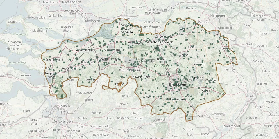 © OpenStreetMap
- Berlicum Roman Catholic Church CemeteryGPS coordinates: 51.67588° N, 5.40160° E
- Stichting Sint-Catharina ChurchyardGPS coordinates: 51.43360° N, 5.47710° E
- Onze Lieve Vrouwe CemeteryGPS coordinates: 51.47646° N, 5.63222° E
- Beek en Donk St. Leonard CemeteryGPS coordinates: 51.53960° N, 5.62580° E
- Made General CemeteryGPS coordinates: 51.67098° N, 4.77949° E
- Kerkpad Cemetery, OverloonGPS coordinates: 51.57200° N, 5.94770° E
- De Oude TorenGPS coordinates: 51.52670° N, 5.62940° E
- Lieshout CentrumGPS coordinates: 51.51843° N, 5.59365° E
- Sint Willibrordus Catholic CemeteryGPS coordinates: 51.41425° N, 5.82009° E
- Begraafplaast Sint Petrus - BandenGPS coordinates: 51.57774° N, 5.18445° E
- Aarle-Rixtel ChurchyardGPS coordinates: 51.51024° N, 5.63842° E
- Presentation of Holy Mary Parish Churchyard, AstenGPS coordinates: 51.40146° N, 5.74406° E
- Budel DorpleinGPS coordinates: 51.23960° N, 5.58858° E
- Helmond Molenstraat Roman Catholic CemeteryGPS coordinates: 51.47800° N, 5.66790° E
- Mary Magdalene Church Cemetery, RijenGPS coordinates: 51.59120° N, 4.91990° E
- St. Laurentius Roman Catholic CemeteryGPS coordinates: 51.59770° N, 6.01334° E
- St. Martin Churchyard, Sint-OedenrodeGPS coordinates: 51.56297° N, 5.46201° E
- Liesbosch CemeteryGPS coordinates: 51.57270° N, 4.69700° E
- Heike Cemetery, TilburgGPS coordinates: 51.55532° N, 5.07808° E
- St. Peter in Chains Churchyard, BergeijkGPS coordinates: 51.32107° N, 5.35856° E
- Katwijk CemeteryGPS coordinates: 51.75065° N, 5.87087° E
- Sint Jans Onthoofding Roman Catholic CemeteryGPS coordinates: 51.54394° N, 5.18653° E
- Breda Zuylen Roman Catholic CemeteryGPS coordinates: 51.57934° N, 4.74897° E
- Helmond Reformed CemeteryGPS coordinates: 51.47819° N, 5.66928° E
- Breda Vogelenzang CemeteryGPS coordinates: 51.56871° N, 4.79125° E
- De Huikert Cemetery, GerwenGPS coordinates: 51.49195° N, 5.56410° E
- Broekhoven Roman Catholic CemeteryGPS coordinates: 51.54480° N, 5.08860° E
- Den Dungen Roman Catholic Church ChurchyardGPS coordinates: 51.66430° N, 5.36830° E
- Bergen-op-Zoom Canadian War CemeteryGPS coordinates: 51.50125° N, 4.32889° E
- Leijsenakkers CemeteryGPS coordinates: 51.64577° N, 4.87286° E