
Lublin Voivodeship
1,041 known cemeteries in Lublin Voivodeship, Poland.
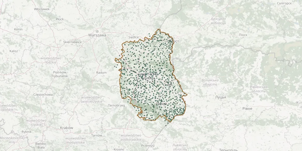 © OpenStreetMap
- Wola Duża Historic Greek Catholic CemeteryGPS coordinates: 50.30801° N, 23.39583° E
- Wola Korybutowa Parish CemeteryGPS coordinates: 51.22786° N, 23.08467° E
- Wola Krasienińska Parish CemeteryGPS coordinates: 51.35981° N, 22.47065° E
- Wola Osowińska Parish CemeteryGPS coordinates: 51.73291° N, 22.47653° E
- Wola Rudzka World War I Cemetery (former Orthodox)GPS coordinates: 51.16075° N, 21.97580° E
- Wola Wereszczyńska Old Parish CemeteryGPS coordinates: 51.42633° N, 23.14409° E
- Wola Wereszczyńska Parish CemeteryGPS coordinates: 51.42801° N, 23.13639° E
- Wólka Dobryńska Roman Catholic CemeteryGPS coordinates: 52.03397° N, 23.48582° E
- Wólka Komarowska German War Cemetery (World War I)GPS coordinates: 51.81937° N, 22.95339° E
- Wólka Kraśniczyńska Parish CemeteryGPS coordinates: 50.93282° N, 23.37756° E
- Wólka Łosiniecka War Cemetery (September 1939)GPS coordinates: 50.42853° N, 23.29404° E
- Wólka Ratajska Parish CemeteryGPS coordinates: 50.72796° N, 22.46300° E
- Wołoskowola Former Orthodox CemeteryGPS coordinates: 51.49423° N, 23.22272° E
- Woskrzenice Duże Parish CemeteryGPS coordinates: 52.04208° N, 23.25989° E
- Woskrzenice Małe Soviet Prisoner-of-War CemeteryGPS coordinates: 52.04909° N, 23.24130° E
- Wożuczyn Parish CemeteryGPS coordinates: 50.55942° N, 23.58904° E
- Wrzelowiec Parish CemeteryGPS coordinates: 51.09022° N, 21.92966° E
- Wygnanka Epidemic CemeteryGPS coordinates: 51.92256° N, 22.75200° E
- Wygnanowice CemeteryGPS coordinates: 51.07628° N, 22.83855° E
- Wyryki-Adampol Orthodox CemeteryGPS coordinates: 51.55611° N, 23.42944° E
- Wyryki Orthodox CemeteryGPS coordinates: 51.56386° N, 23.35573° E
- Wysokie Roman Catholic CemeteryGPS coordinates: 50.91333° N, 22.66528° E
- Wytyczno Border Protection Corps War CemeteryGPS coordinates: 51.44096° N, 23.24309° E
- Wytyczno Evangelical Cantorate Cemetery, 19th-20th CenturyGPS coordinates: 51.42826° N, 23.27090° E
- Wytyczno Orthodox CemeteryGPS coordinates: 51.44140° N, 23.24271° E
- Wytyczno Parish CemeteryGPS coordinates: 51.43801° N, 23.25211° E
- Wyżłów Parish CemeteryGPS coordinates: 50.45116° N, 24.03193° E
- Żabianka Parish CemeteryGPS coordinates: 51.58647° N, 22.08609° E
- Żabia Wola CemeteryGPS coordinates: 51.11868° N, 22.50665° E
- Zaczopki Russian and German War Cemetery from 1915GPS coordinates: 52.16640° N, 23.39026° E