
Kyiv Oblast
592 known cemeteries in Kyiv Oblast, Ukraine.
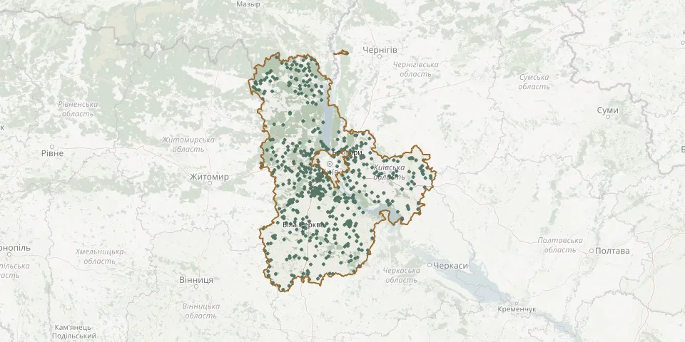 © OpenStreetMap
- Brovary CemeteryGPS coordinates: 50.50354° N, 30.79359° E
- Brovary Cemetery No. 3GPS coordinates: 50.52278° N, 30.84398° E
- Brovary New CemeteryGPS coordinates: 50.52106° N, 30.84685° E
- Bucha North-East CemeteryGPS coordinates: 50.55922° N, 30.23761° E
- Buchanskyi CemeteryGPS coordinates: 50.45059° N, 30.08281° E
- Bucha South CemeteryGPS coordinates: 50.53529° N, 30.20784° E
- Budaivskyi CemeteryGPS coordinates: 50.30550° N, 30.31343° E
- Buhaivskyi Small CemeteryGPS coordinates: 50.20571° N, 30.38532° E
- Buriakivske CemeteryGPS coordinates: 51.37685° N, 29.92071° E
- Burkivtsi CemeteryGPS coordinates: 49.43239° N, 29.59412° E
- Burty CemeteryGPS coordinates: 49.84053° N, 30.91304° E
- Bushevskoe CemeteryGPS coordinates: 50.33809° N, 30.02105° E
- Buzova CemeteryGPS coordinates: 50.41138° N, 30.04917° E
- Bychkivske CemeteryGPS coordinates: 51.21547° N, 29.88963° E
- Byshiv CemeteryGPS coordinates: 50.26182° N, 29.89291° E
- Cemetery near BorovaGPS coordinates: 50.13294° N, 30.09708° E
- Cemetery near HorenychiGPS coordinates: 50.44877° N, 30.22253° E
- Cemetery near KaharlykGPS coordinates: 49.85081° N, 30.74824° E
- Cemetery near KyivGPS coordinates: 50.35226° N, 30.46706° E
- Cemetery near LyubchaGPS coordinates: 49.50767° N, 30.16707° E
- Cemetery near MyronivkaGPS coordinates: 49.59582° N, 31.10443° E
- Cemetery near NedraGPS coordinates: 50.33581° N, 31.54420° E
- Cemetery near PetrushkyGPS coordinates: 50.39643° N, 30.14098° E
- Cemetery near SkvyraGPS coordinates: 49.70379° N, 29.81677° E
- Cemetery near SkvyraGPS coordinates: 49.71524° N, 29.67804° E
- Cemetery near VasylkivGPS coordinates: 50.02032° N, 30.35083° E
- Cemetery near VorzelGPS coordinates: 50.57869° N, 30.12802° E
- Cemetery near ZahaltsiGPS coordinates: 50.68833° N, 29.82791° E
- Cemetery next to ZavalivkaGPS coordinates: 50.42349° N, 29.72442° E
- Chapaievske CemeteryGPS coordinates: 51.42465° N, 30.32110° E