
Michoacán
108 known cemeteries in Michoacán, Mexico.
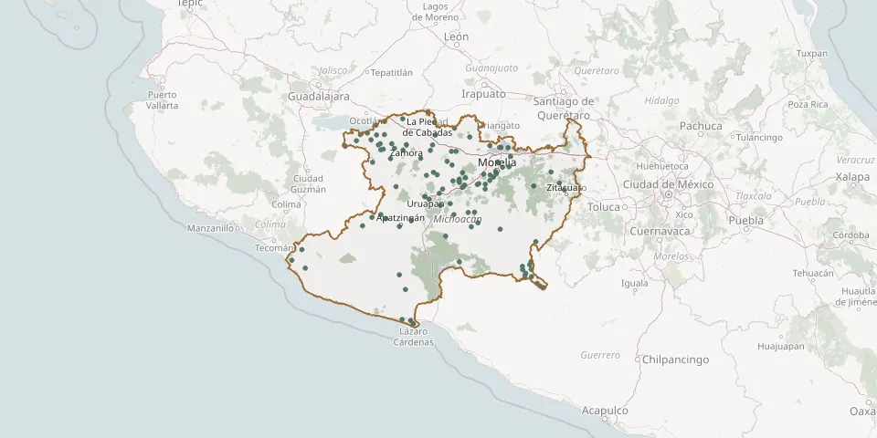 © OpenStreetMap
- Acalpican CemeteryGPS coordinates: 18.01067° N, 102.33926° W
- Acuitzeramo Cemetery No. 1GPS coordinates: 19.99677° N, 101.97046° W
- Acuitzio del Canje Municipal CemeteryGPS coordinates: 19.49911° N, 101.33656° W
- Aguirre Cemetery, CharacharandoGPS coordinates: 18.42309° N, 100.71116° W
- Angao CemeteryGPS coordinates: 18.67063° N, 100.78763° W
- Apatzingán Municipal CemeteryGPS coordinates: 19.07243° N, 102.36917° W
- Aquila Municipal CemeteryGPS coordinates: 18.59654° N, 103.50164° W
- Ario de Rosales Municipal CemeteryGPS coordinates: 19.20576° N, 101.71337° W
- Arroyo Hondo CemeteryGPS coordinates: 18.53752° N, 100.85125° W
- Arteaga Municipal CemeteryGPS coordinates: 18.35541° N, 102.29901° W
- Briseñas Municipal Cemetery (El Refugio)GPS coordinates: 20.26078° N, 102.55032° W
- Buenavista Tomatlán Municipal CemeteryGPS coordinates: 19.20700° N, 102.59324° W
- Chapitiro Regional CemeteryGPS coordinates: 19.92565° N, 101.69011° W
- Charo Municipal CemeteryGPS coordinates: 19.74861° N, 101.05125° W
- Chavinda CemeteryGPS coordinates: 20.01111° N, 102.46117° W
- Cherán Municipal CemeteryGPS coordinates: 19.68812° N, 101.95973° W
- Chilchota Municipal CemeteryGPS coordinates: 19.84447° N, 102.11272° W
- Churumuco de Morelos Municipal CemeteryGPS coordinates: 18.67131° N, 101.64955° W
- Cojumatlán de Régules Cemetery No. 2GPS coordinates: 20.11434° N, 102.84069° W
- Cotija de la Paz New Municipal CemeteryGPS coordinates: 19.79996° N, 102.69277° W
- Dolores CemeteryGPS coordinates: 19.68943° N, 100.54807° W
- Dos Estrellas CemeteryGPS coordinates: 19.93426° N, 101.99868° W
- El Bejuco CemeteryGPS coordinates: 19.08112° N, 102.81195° W
- El Capulín de San Felipe de los Alzati CemeteryGPS coordinates: 19.48668° N, 100.38532° W
- El Ranchito CemeteryGPS coordinates: 18.68759° N, 103.66368° W
- El Rosario CemeteryGPS coordinates: 18.52234° N, 100.85788° W
- Erongarícuaro Municipal CemeteryGPS coordinates: 19.59075° N, 101.72510° W
- Felipe Carrillo Puerto Main CemeteryGPS coordinates: 19.17780° N, 102.69847° W
- Guaracha CemeteryGPS coordinates: 19.94805° N, 102.56356° W
- Huandacareo Municipal CemeteryGPS coordinates: 19.99141° N, 101.28373° W