
Michoacán
108 known cemeteries in Michoacán, Mexico.
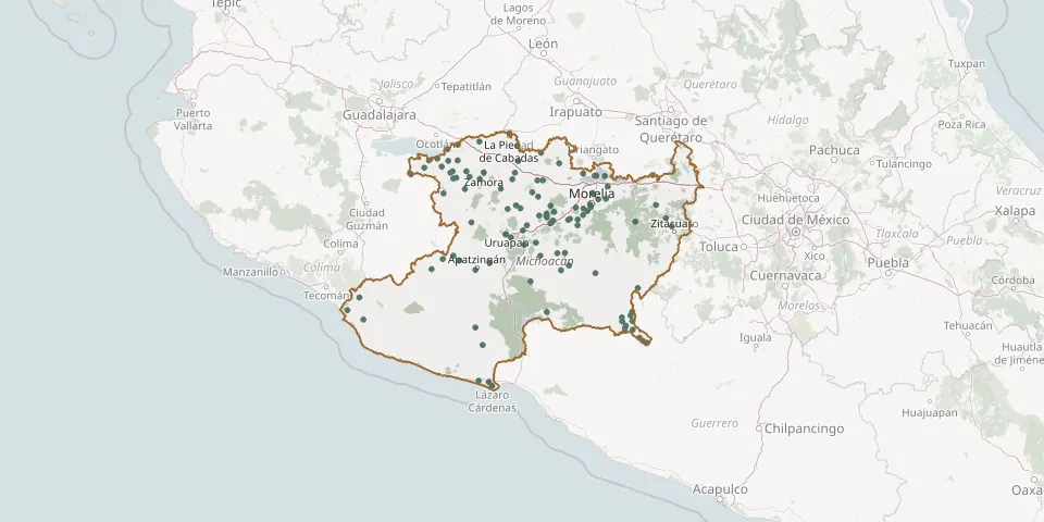 © OpenStreetMap
- Pacanda CemeteryGPS coordinates: 19.60702° N, 101.65166° W
- Pajacuarán Municipal CemeteryGPS coordinates: 20.11545° N, 102.54873° W
- Palos Marías CemeteryGPS coordinates: 18.80922° N, 103.54401° W
- Paracho CemeteryGPS coordinates: 19.65330° N, 102.04625° W
- Parácuaro Municipal CemeteryGPS coordinates: 19.14146° N, 102.22922° W
- Pátzcuaro Municipal CemeteryGPS coordinates: 19.51955° N, 101.61289° W
- Penjamillo de Degollado Municipal CemeteryGPS coordinates: 20.10849° N, 101.93697° W
- Peribán CemeteryGPS coordinates: 19.52646° N, 102.41088° W
- Pregreso Nacional Municipal CemeteryGPS coordinates: 19.99942° N, 102.28555° W
- Purechucho CemeteryGPS coordinates: 18.58178° N, 100.88741° W
- Ramona Guaracha Cemetery, Emiliano ZapataGPS coordinates: 19.99906° N, 102.62342° W
- Sahuayo Municipal CemeteryGPS coordinates: 20.05673° N, 102.71241° W
- San Ángel Zurumucapio CemeteryGPS coordinates: 19.44937° N, 101.89268° W
- San Antonio de Padua CemeteryGPS coordinates: 19.86631° N, 101.03244° W
- San Antonio Villalongín CemeteryGPS coordinates: 19.53262° N, 100.75598° W
- San Blas CemeteryGPS coordinates: 18.00039° N, 102.23553° W
- San Jerónimo Purenchécuaro Communal CemeteryGPS coordinates: 19.68491° N, 101.61141° W
- San José de Gracia CemeteryGPS coordinates: 19.99150° N, 103.02874° W
- San Juan Evangelista Neighbourhood Municipal CemeteryGPS coordinates: 19.41114° N, 102.06832° W
- San Lucas Municipal CemeteryGPS coordinates: 18.58250° N, 100.78380° W
- San Mauro CemeteryGPS coordinates: 19.23634° N, 101.46456° W
- San Pedro Cahro Municipal CemeteryGPS coordinates: 20.11215° N, 102.64414° W
- Santa Ana Amatlán Municipal CemeteryGPS coordinates: 19.16096° N, 102.53357° W
- Santa Cruz De Villagomez CemeteryGPS coordinates: 18.37616° N, 100.63600° W
- Santiago Conguripo CemeteryGPS coordinates: 20.18604° N, 101.70870° W
- Santiago Tangamandapio Municipal CemeteryGPS coordinates: 19.96102° N, 102.42900° W
- Santiago Undameo CemeteryGPS coordinates: 19.59556° N, 101.28136° W
- Tacícuaro CemeteryGPS coordinates: 19.66832° N, 101.35621° W
- Tanhuato de Guerrero Municipal CemeteryGPS coordinates: 20.29390° N, 102.33028° W
- Tarecuato CemeteryGPS coordinates: 19.84130° N, 102.47747° W