
Limburg
316 known cemeteries in Limburg, Belgium.
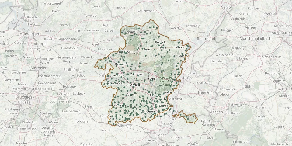 © OpenStreetMap
- Kotem CemeteryGPS coordinates: 50.94777° N, 5.74201° E
- Kozen ChurchyardGPS coordinates: 50.87563° N, 5.23993° E
- Kwaadmechelen CemeteryGPS coordinates: 51.10020° N, 5.14893° E
- Lanaken CemeteryGPS coordinates: 50.89330° N, 5.64944° E
- Lanaye CemeteryGPS coordinates: 50.78200° N, 5.69638° E
- Lanklaar CemeteryGPS coordinates: 51.01821° N, 5.72429° E
- Lauw CemeteryGPS coordinates: 50.73940° N, 5.41435° E
- Leopoldsburg Belgian Military CemeteryGPS coordinates: 51.11138° N, 5.26624° E
- Leopoldsburg CemeteryGPS coordinates: 51.11593° N, 5.25275° E
- Leopoldsburg Commonwealth Military CemeteryGPS coordinates: 51.11231° N, 5.26842° E
- Leut CemeteryGPS coordinates: 50.99107° N, 5.74354° E
- Leut Old ChurchyardGPS coordinates: 50.99157° N, 5.73694° E
- Lindel Overpelt CemeteryGPS coordinates: 51.19381° N, 5.41102° E
- Linde Peer ChurchyardGPS coordinates: 51.09598° N, 5.44345° E
- Linkhout CemeteryGPS coordinates: 50.96677° N, 5.13554° E
- Loksbergen CemeteryGPS coordinates: 50.93481° N, 5.07062° E
- Lommel Centrum CemeteryGPS coordinates: 51.22066° N, 5.34374° E
- Lommel KerkhovenGPS coordinates: 51.16600° N, 5.26770° E
- Lommel Kolonie Municipal CemeteryGPS coordinates: 51.25167° N, 5.38345° E
- Lommel (Werkplaatsen) Communal CemeteryGPS coordinates: 51.22487° N, 5.26471° E
- Lozen CemeteryGPS coordinates: 51.20305° N, 5.56250° E
- Lummen Brothers' CemeteryGPS coordinates: 50.99359° N, 5.18526° E
- Lummen CemeteryGPS coordinates: 50.99144° N, 5.18400° E
- Maasmechelen CemeteryGPS coordinates: 50.96068° N, 5.68881° E
- Maria-MagdalenakerkGPS coordinates: 50.70730° N, 5.15110° E
- Martenslinde CemeteryGPS coordinates: 50.85254° N, 5.53579° E
- Mechelen-aan-de-Maas Historic CemeteryGPS coordinates: 50.95895° N, 5.70580° E
- Mechelen-Bovelingen Achterstraat CemeteryGPS coordinates: 50.73830° N, 5.26574° E
- Mechelen-Bovelingen Schoolstraat CemeteryGPS coordinates: 50.74092° N, 5.26171° E
- Meeswijk CemeteryGPS coordinates: 51.00282° N, 5.74392° E