
Utrecht
180 known cemeteries in Utrecht, Netherlands.
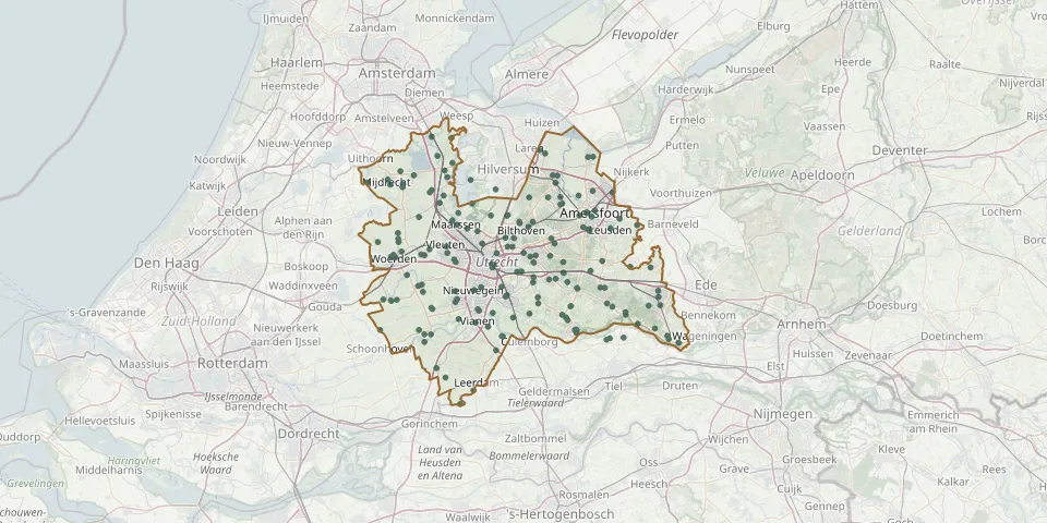 © OpenStreetMap
- Groenewoud CemeteryGPS coordinates: 51.99058° N, 5.32145° E
- Hagestein CemeteryGPS coordinates: 51.98017° N, 5.12100° E
- Harmelen Roman Catholic CemeteryGPS coordinates: 52.09141° N, 4.96040° E
- Hekendorp Public CemeteryGPS coordinates: 52.02253° N, 4.85729° E
- Het EnghenbergjeGPS coordinates: 52.17024° N, 5.30297° E
- Het Hart Roman Catholic Cemetery, SoestGPS coordinates: 52.18070° N, 5.27130° E
- Het Stille HofjeGPS coordinates: 52.14330° N, 5.23283° E
- Hogewal Old General Cemetery, WoerdenGPS coordinates: 52.08794° N, 4.88743° E
- Hogewal Roman Catholic CemeteryGPS coordinates: 52.08856° N, 4.88648° E
- Hooglanderveen Roman Catholic CemeteryGPS coordinates: 52.18770° N, 5.43360° E
- Jaarsveld CemeteryGPS coordinates: 51.96858° N, 4.97672° E
- Jodenbosje Cemetery, MaarssenGPS coordinates: 52.15637° N, 5.04561° E
- Kamerik CemeteryGPS coordinates: 52.11183° N, 4.89528° E
- Kamerik General CemeteryGPS coordinates: 52.11657° N, 4.89462° E
- Kanis Cemetery, KamerikGPS coordinates: 52.12561° N, 4.89340° E
- Kedichem CemeteryGPS coordinates: 51.86003° N, 5.05022° E
- Kerklaan Former Roman Catholic CemeteryGPS coordinates: 52.22237° N, 5.01125° E
- Kerkveld General CemeteryGPS coordinates: 52.03718° N, 5.08574° E
- Lage-Vuursche ChurchyardGPS coordinates: 52.18051° N, 5.22386° E
- Lambalgen CemeteryGPS coordinates: 52.07340° N, 5.47887° E
- Langbroek General CemeteryGPS coordinates: 52.01223° N, 5.32908° E
- Langbroek Reformed Congregation CemeteryGPS coordinates: 52.01173° N, 5.32817° E
- Leersum New CemeteryGPS coordinates: 52.01638° N, 5.41974° E
- Leersum Old CemeteryGPS coordinates: 52.01130° N, 5.43410° E
- Leidsestraatweg General CemeteryGPS coordinates: 52.09266° N, 4.95207° E
- Lingedijk Old CemeteryGPS coordinates: 51.88110° N, 5.08395° E
- Loenen aan de Vecht CemeteryGPS coordinates: 52.21182° N, 5.01756° E
- Loosdrecht de Rading General CemeteryGPS coordinates: 52.19305° N, 5.13993° E
- Loosdrecht Protestant CemeteryGPS coordinates: 52.20750° N, 5.07660° E
- Lopik ChurchyardGPS coordinates: 51.97520° N, 4.94700° E